Jolarpettai

| Jolarpettai ஜோலார்பேட்டை Jolarpet | |
|---|---|
| Town | |
|
| |
 Jolarpettai Location in Tamil Nadu, India | |
| Coordinates: 12°34′N 78°35′E / 12.56°N 78.58°ECoordinates: 12°34′N 78°35′E / 12.56°N 78.58°E | |
| Country |
|
| State | Tamil Nadu |
| District | Vellore |
| Government | |
| • Type | Second Grade Municipality |
| • Body | Jolarpet Municipality |
| • Chairman | S. Vasumathi Srinivasan[1] |
| Area | |
| • Total | 13.06 km2 (5.04 sq mi) |
| Elevation | 417 m (1,368 ft) |
| Population (2011) | |
| • Total | 29,662 |
| • Density | 2,300/km2 (5,900/sq mi) |
| Languages | |
| • Official | Tamil |
| Time zone | IST (UTC+5:30) |
| PIN | 635851 |
| Telephone code | 04179 |
| Vehicle registration | TN-83 |
| Nearest city | Vellore |
| Lok Sabha constituency | Thiruvannamalai |
| Vidhan Sabha constituency | Jolarpet |
| Website | http://municipality.tn.gov.in/jolarpet |
Jolarpettai is a municipality town in Vellore district, Tamil Nadu, India upgraded to IInd grade municipality from October 2010. It has the major intercity train station and a major commuter rail hub in Southern Railway. It is 7 km from Tirupattur and 18 km from Vaniyambadi.
Jolarpet Municipality was constituted in 1971 from 23.5.1971 as First Grade Town Panchayat Selection Grade Town Panchayat 1982 from 24.02 1982 and then it was upgraded to Third Grade Municipality from 01.07 2004 and it was subsequently upgraded as IInd Grade Municipality Vide GO(Ms) No. 154 Dt. 09.08 2010. As of 2011, the town had a population of 29,662 and covered an area of 13.06. km2. The town is divided into 18 wards.[2] The Municipal Council comprises 18 wards. Councillors is headed by chairperson, who is elected by voters of the councillors. The municipal office is situated at Gandhi Road near by Jolarpet Railway junction.
Geography
Jolarpet is a second grade municipal town in the main railway corridor connecting Chennai – Bangalore, is 212 km from Chennai, the State Capital in the south western direction and it is 80 km from Vellore (District Headquarters town) on the western side.[3]
Jolarpet is renowned for its strategic location on the rail route and its railway station.
The town is also located on State Highway 18 connecting Vaniyambadi -Tirupattur. Regarding transportation linkage, the highway (NH 46) from Chennai to Krishnagiri passes through the outskirts of the town and there are another two roads originating from the centre of the town. Jolarpet is in Tirupattur Taluk and is situated near the Jolarpet Railway Junction.[4]
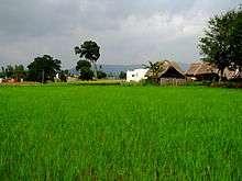
Jolarpettai municipality comprises four revenue villages, namely, Vakkanampatti, Ediyampatti Ossinattam Vattam, Kudiyana Kuppam, and spreads over an area of 13.06 km2. Location of Yelagiri hills close with the town supports growth of the town to a greater extent.[3]
Almost the whole of Jolarpet Municipality consists of flat terrain. The general slope is towards southeast and the small streams that rise in the Yelagiri hills situated in the west eventually fall into the Palar river. The topography of Jolarpet in plain and it is situated at an altitude of 186.75 meters above mean sea level. The wind direction is predominant towards southwest for the whole of the year However, during summer it is from southwest to northeast.
Demographics
According to 2011 census, Jolarpet had a population of 29,662 with a sex-ratio of 1,032 females for every 1,000 males, much above the national average of 929.[5] A total of 3,148 were under the age of six, constituting 1,605 males and 1,543 females. Scheduled Castes and Scheduled Tribes accounted for 17.89% and 1.79% of the population respectively. The average literacy of the town was 74.44%, compared to the national average of 72.99%.[5] The town had a total of : 7140 households. There were a total of 10,639 workers, comprising 220 cultivators, 632 main agricultural labourers, 1,211 in house hold industries, 6,327 other workers, 2,249 marginal workers, 20 marginal cultivators, 274 marginal agricultural labourers, 269 marginal workers in household industries and 1,686 other marginal workers.[6] As per the religious census of 2011, Jolarpet had 91.87% Hindus, 4.44% Muslims, 3.55% Christians, 0.02% Sikhs, 0.02% Buddhists, 0.0% Jains, 0.09% following other religions and 0.01% following no religion or did not indicate any religious preference.[7]
History
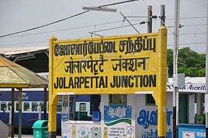
Jolarpettai town, a prime junction served by Southern Railways, is virtually bisected by Chennai–Bangalore railway line which runs almost in the middle of the town. Though the beginning of the town was as a humble hamlet, the town had gradually evolved into an important railway node on establishment of the railway junction.The history of Jolarpettai Junction goes back to 1860s but the existence of the settlement dates back still further. When Madras Railways is started in 1856, trains plied between Royapuram(Madras) to Wallajah Road(Arcot). Later,work was started for laying the rail line in 1864 in the Wallajah Road - Bangalore Contonement route via Jollarpet in which Bangalore mail started its journey in 1868. The Brindavan Express when introduced in the late 1960s was considered one of the fastest train at that time which crosses the Jolarpettai - Bangalore cantonment section in 1hour 30 min.
Politics
K.C. Veeramani[8] is the M.L.A for the Jolarpet Constituency[9] after the 2011 assembly election. And he belongs to AIADMK.
The Assembly constituency for Natrampalli was now renamed as Jolarpet constituency. This is the 49th Tamil Assembly constituency. Areas coming under Jolarpet constituencies[10]
Transport
Jolarpettai is well connected by road to various parts of Vellore district. The State Highway 18 (Salem-Vaniyambadi) passes through the town, while NH 46 (Krishnagiri-Walajapet), which is part of the Golden Quadrilateral project, passes through the town's outskirts. It is well connected to all parts of Vellore district as well as important towns in Krishnagiri district and Dharmapuri district and Bangalore by buses.
Jolarpet Junction is one of the biggest Railway Junction in Tamil Nadu State. It connects the states of Kerala, Karnataka and Andhra Pradesh, which is a major cause of the town’s development. The presence of a State Highway adds advantage to the town. Thus, the town takes in the advantage of both road and rail.[11]
The public transport in Jolarpet is served by Indian railways apart from the Tamil Nadu transport corporation buses. Jolarpet is one of the oldest towns in south India. It is the second largest Railway Junction in vellore district, next to Vellore-Katpadi Junction. This place is the crossroads for south-west- and south-east-bound trains. Trains from north and east India pass by this way to Salem/Bangalore.
Jolarpettai Junction is one of the Class A junctions in the Southern Railways which is the 'Border' station of Chennai Division.Earlier most trains used to change crew at this station which is not the case now. This junction has all the facilities of workshop, shelter for the goods trains. This junction has the ticket counter in the first floor on the bridge. This junction has two bridges, one with steps, and another with a ramp which connects the two villages of the town, Kodiyur and Eadayampatti. Since 121 trains [12] pass per day at average some of trains do not stop due to rail traffic congestion such as Nilgiri Express (daily), Mangalore Fast Express (daily), Trivandrum Mail (daily) and weekly Express Tirupati, Coimbatore Express, Mangalore-Sangatrachi Express, Swarna Jayanthi Express, VIA Tirupattur weekly Express Vivek Express, Madurai-Dwarka Express, Velankanni-vasco da gama express, Hubli Express.
There are no airport in Jolarpet but the nearest airport is Kempegowda International Airport at Bangalore, which is 185 kilometres (115 mi) from the town.
Climate and rainfall
The seasonal climate conditions are moderate. Weather is colder during winter and hotter in summer due to hills and forests surrounding the town.
The average maximum and minimum temperature are 42 °C and 13 °C respectively. The town typically receives a maximum rainfall of 35 cm, 37 cm during the September, October and November. Light moderate rainfall of 10 cm to 32 cm occurs during the months of June, July & August.
The wind direction during April to September is southwest. September is usually a still cold month, with light and varying winds by October the winds shifts to northeast succeeded by north-east monsoon and winter season begins. The south-west wind begins to carry on the southwest monsoon with occasional showers up to August.
Culture
The town does not have important places of tourism prominence within their limits but the important tourist places of the region are in close vicinity to the town. As the town has better facilities to reside, the number of tourists visiting the town are more. The picturesque hill station of Yelagiri is 14 km from Jolarpettai. Vainu Bappu Observatory, 46 km away, is another important place of tourist interest.[13]
See also
External links
References
- ↑ Jolarpet municipality
- ↑ About Jolarpet municipality
- 1 2 Jolarpet History
- ↑ Jolarpet History
- 1 2 "Census Info 2011 Final population totals". Office of The Registrar General and Census Commissioner, Ministry of Home Affairs, Government of India. 2013. Retrieved 26 January 2014.
- ↑ "Census Info 2011 Final population totals - Jolarpet". Office of The Registrar General and Census Commissioner, Ministry of Home Affairs, Government of India. 2013. Retrieved 26 January 2014.
- ↑ "Population By Religious Community - Tamil Nadu" (XLS). Office of The Registrar General and Census Commissioner, Ministry of Home Affairs, Government of India. 2011. Retrieved 13 September 2015.
- ↑ 2011 Tamilnadu state election results
- ↑
- ↑ Areas coming under Vaniyambadi, Ambur, Jolarpet, Tirupattur constituencies
- ↑ Jolarpet Transport
- ↑ List of trains that pass via JOLARPETTAI
- ↑ Jolarpet Tourisam
| State symbols |
|
|---|---|
| Governance |
|
| Topics | |
| Districts |
|
| Major cities | |
| Jolarpet | |||
|---|---|---|---|
| Next station eastbound: Kettandapatti |
West Line, Chennai Suburban | Next station westbound: Thirupattur |
|
| Stop number: 57 | KM from start: 213.02 | ||