Virudhunagar
| Virudhunagar விருதுநகர் | |
|---|---|
| Town | |
|
A view of Main Bazaar street | |
 Virudhunagar | |
| Coordinates: 9°35′N 77°57′E / 9.583°N 77.950°ECoordinates: 9°35′N 77°57′E / 9.583°N 77.950°E | |
| Country | India |
| State | Tamil Nadu |
| District | Virudhunagar |
| Government | |
| • Type | Selection Grade Municipality |
| • Body | Virudhunagar municipality |
| Area | |
| • Total | 6.39 km2 (2.47 sq mi) |
| Population (2011) | |
| • Total | 72,296 |
| • Density | 11,000/km2 (29,000/sq mi) |
| Languages | |
| • Official | Tamil |
| Time zone | IST (UTC+5:30) |
| PIN | 626 001 |
| Telephone code | 04562 |
| Vehicle registration | TN-67 |
.JPG)
Virudhunagar, formerly known as Virudhupatti, is a town and the administrative headquarters of the Virudhunagar district in the South Indian state of Tamil Nadu. It is located 506 km (314 mi) southwest of the state capital Chennai and 53 km (33 mi) south of Madurai. Virudhunagar emerged as an important trade centre during the British rule. The town is the birthplace of freedom fighter K. Kamaraj, former chief minister of Tamil Nadu, and Bharat Ratna recipient. Located to the east of Kowsika River, Virudhunagar has an average elevation of 102 m (335 ft) above sea level and is largely flat with no major geological formations. The town has a humid climate and receives 780 mm (31 in) rainfall annually. Virudhunagar was a part of Madurai and has been ruled at various times by Later Pandyas, Vijayanagar Empire, Madurai Nayaks, Chanda Sahib, Carnatic kingdom and the British.
Virudhunagar is administered by a municipality covering an area of 6.39 km2 (2.47 sq mi). In 2011, the town had a population of 72,296. As the administrative headquarters of the district, the town's economy is based on the service sector, which employs 93 per cent of the total workforce. The remaining 7 per cent is employed in agriculture, mining, quarrying, raising livestock, manufacturing, construction, trade and commerce. Roadways are the main means of transportation, while the town also has rail connectivity. The nearest airport is Madurai Airport, located 45 km (28 mi) north-east of the town. There are 14 secondary schools, two colleges of arts and sciences (one for men and one for women), one polytechnic college and three university study centres.
Etymology and history
According to a local legend, a warrior who won a number of banners (called virudhu in Tamil) from his conquest of kingdoms, came to the town and challenged the residents. A resident accepted the challenge, killed the warrior, and then proceeded to seize the flags held by him. From then on, the town was known as Virudhukkalvetti.[1][2]
Virudhunagar was a part of Madurai region (the region comprising all of Southern Tamil Nadu beyond Trichy in modern times) during the 16th century CE. The region became independent from Vijayanagar Empire in 1559 under the Nayaks.[3] Nayak rule ended in 1736 and the region was repeatedly captured several times by Chanda Sahib (1740 – 1754), Arcot Nawab and Muhammed Yusuf Khan (1725 – 1764) in the middle of 18th century.[4] In 1801, the region came under the direct control of the British East India Company and was annexed to the Madras Presidency.[5]
By the late 19th century, all the castes, especially the Maravars (also called Thevars), were against the Nadars.[6] Nadars were also the majority in religious conversions from Hinduism to Christianity under the influence of the European missionaries. Some of the Nadars who remained in Hinduism sought entry into the temples governed by Maravars, which was denied as Nadars were considered inferior in caste.[7] The mutual confrontation between the two groups reached its peak in the region in 1899, leading to the Sivakasi riots. During the riots, 866 Nadar houses were burnt, seven Nadars and 14 Maravars were killed out of the 21 known deaths. The Maravar retaliated by attacking the Nadars scattered around the region killing three Nadars. Eventually the riots came to an end after the intervention of the military in mid-July 1899.[8][9]
The town's name was changed to Virudhupatti in 1875 and on 6 April 1923, the town council renamed it Virudhunagar. It was an important trading centre during the British rule and the merchandise from Virudhunagar was exported overseas through the ports of Kulasekharapatnam, Thoothukudi, Vaippar and Devipattinam. The town is the birthplace of K. Kamaraj, a freedom fighter, Chief Minister of Tamil Nadu from 1954 to 1963 and a recipient of the Bharat Ratna, India's highest civilian award.[1][2]
Geography
| Virudhunagar | ||||||||||||||||||||||||||||||||||||||||||||||||||||||||||||
|---|---|---|---|---|---|---|---|---|---|---|---|---|---|---|---|---|---|---|---|---|---|---|---|---|---|---|---|---|---|---|---|---|---|---|---|---|---|---|---|---|---|---|---|---|---|---|---|---|---|---|---|---|---|---|---|---|---|---|---|---|
| Climate chart (explanation) | ||||||||||||||||||||||||||||||||||||||||||||||||||||||||||||
| ||||||||||||||||||||||||||||||||||||||||||||||||||||||||||||
| ||||||||||||||||||||||||||||||||||||||||||||||||||||||||||||
Virudhunagar municipality covers an area of 6.39 km2 (2.47 sq mi)[11] It is located 506 km (314 mi) southwest of the state capital Chennai and 53 km (33 mi) south of Madurai. The city has an average elevation of 102 m (335 ft). The town is located to the east of the Kowsika River and to the west of the Madurai–Tirnelveli railway line. The topology is largely flat, with no major geological formations. The soil types are black and red, which are conducive for crops like cotton, chillies, spices, cardamom and millet. Paddy and sugar cane are grown in places where motor pumps are available for irrigation. Like the rest of the state, Virudhunagar experiences hot weather between April and June and is relatively cooler in December and January. The average daily temperature ranges from a maximum of 38.5 °C (101.3 °F) to a minimum of 30 °C (86 °F). The town receives an annual average rainfall of 829.6 mm (32.66 in), which is less than the state average of 1,008 mm (39.7 in). The South-west monsoon, which begins in June and lasts until August, brings little rain. Most of the rain is received during the North-east monsoon in the months of October, November and December.[10][11][12][13][14] Lime, locally called Limekankar, is the major mineral available in Virudhunagar, which is utilised by Tamil Nadu Cements, a Government of Tamil Nadu undertaking located in Sivakasi and Madras Cements, a private sector plant located in Tulukkapatti village in Virudhunagar.[15]
Demographics and economy
| Historical population | ||
|---|---|---|
| Year | Pop. | ±% |
| 1951 | 46,456 | — |
| 1961 | 54,871 | +18.1% |
| 1971 | 61,904 | +12.8% |
| 1981 | 68,040 | +9.9% |
| 1991 | 70,971 | +4.3% |
| 2001 | 72,081 | +1.6% |
| 2011 | 72,296 | +0.3% |
Sources:
| ||
According to 2011 census, Virudhunagar had a population of 72,296 with a sex-ratio of 1,014 females for every 1,000 males, much above the national average of 929.[17] A total of 6,454 were under the age of six, constituting 3,268 males and 3,186 females. Scheduled Castes and Scheduled Tribes accounted for 7.06% and .08% of the population respectively. The average literacy of the town was 84.28%, compared to the national average of 72.99%.[17] The town had a total of 19841 households. There were a total of 27,533 workers, comprising 54 cultivators, 64 main agricultural labourers, 703 in house hold industries, 25,266 other workers, 1,446 marginal workers, 17 marginal cultivators, 10 marginal agricultural labourers, 66 marginal workers in household industries and 1,353 other marginal workers.[18] As of 2004, twelve recognized slums and eleven unrecognised slums were identified in the town, and a total of 17,787 people resided in the slums. The slum population was predominantly employed as daily labourers.[19] The population density was 114 persons per hectare in 2001.[20]
As per the religious census of 2011, Virudhunagar (M) had 85.02% Hindus, 7.73% Muslims, 7.09% Christians, 0.02% Sikhs and 0.14% following other religions.[21]
As of 2008, a total of 228.5 ha (565 acres) constituting 35.72 per cent of the land in Virudhunagar was used for residential purposes, 27 ha (67 acres) constituting 4.22 per cent for commercial use, 99.5 ha (246 acres) constituting 15.6 per cent for industrial space, 26.21 ha (64.8 acres) constituting 2.81 per cent for public and semi-public use, 17.98 ha (44.4 acres) constituting 2.81 per cent for educational purposes and 195.79 ha (483.8 acres) constituting 30.6 per cent for non-urban purposes like agriculture and irrigation.[22]
Economy
Virudhunagar is a marketing and service town for the surrounding areas. As the administrative headquarters of the district, the economy of the town is based on the service sector, with 93 per cent of the workforce employed there as of 2001. The rest of the workforce is employed in agriculture, mining, quarrying, raising livestock, manufacturing, construction, trade and commerce. In 2001, 5.4 per cent of the workforce was employed in the industrial sector, making it the second-largest sector. There is little agricultural activity in the town on account of weather and irrigation facilities,[1] and the town has a set of oil mills and match factories within the town limits.[23] The major commercial activities are concentrated around Katchery Road, Pullalakottai Road and the main bazaar.[24] In 2001, the percentage of the workforce in the service sector had increased from the previous decade. The agricultural output of the town is limited because the local geography and unfavourable climate for growing crops.[1] All major nationalised banks like State Bank of India, Indian Bank, Central Bank of India, Punjab National Bank, Indian Overseas Bank, and private banks like ICICI Bank, City Union Bank and Axis Bank have branches in Virudhunagar. All of these banks have ATMs located in various parts of the town.[25] Virudhunagar is famous for Commission Marketing's of all Kinds of Millets,Cotton,Edible Oils .
Municipal administration and politics
| Municipality officials | |
|---|---|
| Chairman | G. Shanti[26] |
| Commissioner | A. Sardar[27] |
| Vice-Chairman | S. Mariappan[28] |
| Elected members | |
| Member of Legislative Assembly | A.V.R.Srinivasan[29] |
| Member of Parliament | T. Radhakrishnan[30] |
The Virudhunagar municipality (formerly Virudupatti municipality) was established in 1915 as a third-grade municipality. It was upgraded to second-grade in 1956 and then to special grade in 1998.a The municipality has 36 wards, and there is an elected councillor for each ward.[31] The functions of the municipality are devolved into six departments: general administration/personnel, engineering, revenue, public health, city planning and information technology (IT). All these departments are under the control of a municipal commissioner.[32] The legislative powers are vested in a body of 36 members, one from each of the 36 wards.[33] The legislative body is headed by an elected chairperson, who is assisted by a deputy chairperson.[34]
Virudhunagar comes under the Virudhunagar assembly constituency and it elects a member to the Tamil Nadu Legislative Assembly once every five years.[35] The assembly seat was won once each by Dravida Munnetra Kazhagam (DMK) (1996), ICS (SCS) (1991), Desiya Murpokku Dravida Kazhagam (DMDK) (2011), Janata Party (1984), Marumalarchi Dravida Munnetra Kazhagam (MDMK) (2006), Tamil Maanila Congress (TMC) (2001) and Indian National Congress (INC) (1989), and twice by All India Anna Dravid Munnetra Kazhagam (AIADMK) (1977 and 1980).[36] The current MLA of the constituency is K. Pandiarajan from DMDK.[29]
During the 1957 elections, Virudhunagar was a part of Srivilliputhur constituency and was held by the INC and an independent.[37] During the 1962 elections, the town was a part of Aruppukkottai constituency and was held by the Forward Block party.[38] The town was a part of Virudhunagar Lok sabha constituency during the 1967 elections and was held by the Swatantra Party.[39] The constituency was held by DMK during the 1971 elections,[40] INC during the 1977 elections,[41] and AIADMK during the 1980, 1984, 1989, 1991 and 2014 elections,[42][43][44][45] Communist Party of India (CPI) during 1996 and MDMK during the 1998, 1999 and 2004 elections.[46][47][48][49]
Virudhunagar is now part of the Virudhunagar (Lok Sabha constituency) – it has the following five assembly constituencies – Thiruparankundram, Thirumangalam, Sattur, Virudhunagar, and Aruppukkottai. The current Member of Parliament from the constituency is T. Radhakrishnan from the AIADMK party.[30]
Law and order in Virudhunagar is maintained by the Virudhunagar subdivision of the Tamil Nadu Police, headed by a deputy superintendent. There are three police stations in the town, one of which is an all-women police station. There are special units like prohibition enforcement, district crime, social justice and human rights, district crime records and special branches that operate at the district level police division headed by a superintendent of police.[50]
Transportation
The Virudhunagar municipality maintains a total of 78.923 km (49.040 mi) of roads: 38.36 km (23.84 mi) of concrete roads, 39.428 km (24.499 mi) of bituminous roads, 0.39 km (0.24 mi) of water bound macadam (WBM) roads, 0.488 km (0.303 mi) of earthen roads and 0.257 km (0.160 mi) of other roads.[51] The major roads include National Highway 7 and three district roads that connect Virudhunagar with neighbouring towns like Sivakasi, Madurai, Rajapalayam, Aruppukkottai and Sattur. There is a bypass road located west of the town connecting Virudhunagar to Kallupatti, that reduces traffic inside the town.[52]
Virudhunagar is served by a town bus service, which provides connectivity within the town and the suburbs. There are privately operated mini-bus services that cater to the local transport needs. The main bus stand, located in the centre of the town, has 25 bus bays.[53] The Tamil Nadu State Transport Corporation operates daily services connecting various cities to Virudhunagar. The corporation operates a computerised reservation centre in the main bus stand.[54] The State Express Transport Corporation operates long-distance buses connecting the town to important cities like Chennai, Tiruppur and Thoothukudi.[55] The major inter-city bus routes from the town are to adjacent cities like Madurai, Chennai, Rajapalayam, Tenkasi, Kovilpatti, Tuticorin, Tiruchendur, Nagercoil, Tirunelveli, Aruppukottai and Rameshwaram. The town bus routes to surrounding villages are to Thayilpatti, Vilampatti, Alangulam, Vilampatti, M.Pudupatti, Alamarathupatti and Muthalipatti.[56]
The Virudhunagar railway station is located in the major rail head from Madurai to Kanyakumari. The Southern Railway operates daily express trains to places like Chennai, Tuticorin, Kanyakumari, Tirunelveli, Tenkasi, Guruvayoor, Tirupathi, Mumbai, Trivandrum, Mysuru, Howrah, palakkad, kozhikode, kannur, Mangalore, Madgaon and Nizamuddin. There are passenger trains connecting the town to places like Madurai, Tenkasi, Kollam, Tirunelveli, Kumbakonam, Mayiladuthurai, Erode, Nagercoil and Coimbatore.[56] The nearest airport is Madurai Airport, located 45 km (28 mi) northeast of the town.[57]
Education and utility services
There are 14 secondary schools in Virudhunagar. The town has two arts and science colleges, namely V.H.N.S.N. College and V.V.V. College for Women. V.S.V.N. Polytechnic College is the only polytechnic college in the town. Three university study centres operated by the Tamil Nadu Open University, Annamalai University and Alagappa University are located in the town.[58]
Electricity supply to Virudhunagar is regulated and distributed by the Tamil Nadu Electricity Board (TNEB). The town and its suburbs forms the Virudhunagar Electricity Distribution Circle. A chief distribution engineer is stationed at the regional headquarters.[59] Water supply is provided to the town by the Virudhunagar municipality from three sources, namely Anaikuttam, Karuseri Kalquarry and Sukkravarpatti Summer Storage Tank. During the period 2000–01, a total of 3.86 million litres of water was supplied every day to households in the town.[60] About 35 metric tonnes of solid waste are collected from Virudhunagar every day by door-to-door collection. Subsequently, the sanitary department of the Virudhunagar municipality carries out the source segregation and dumping. The coverage of solid waste management had an efficiency of 100 per cent as of 2001.[61] There is no underground drainage system in the town, and the sewerage system for disposal of sullage is through septic tanks, open drains and public conveniences.[62] The municipality maintains stormwater drains on all municipal roads.[63] There are 35 hospitals in the town, one siddha dispensary and two municipal maternity homes that take care of the healthcare needs of the citizens.[64] There are a total of 2,875 street lamps in the town: 276 sodium lamps, five mercury vapour lamps, 2,592 tube lights and two high-mast beam lamps.[65] The municipality operates three markets, namely, the Municipal Market, Uzhavar Santhai, and Virudhunagar Bazaar Market, that cater to the needs of the town and the surrounding rural areas.[66]
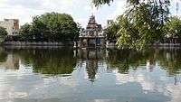
The house of Kamaraj has been converted to a memorial, and it is one of the most prominent visitor attractions in Virudhunagar. The Mariamman Temple, located in the centre of the town, is a famous Hindu temple in the district. The annual temple festival celebrated during March is one of the prominent festivals in the region and attracts lots of visitors.[67]
Notes
Footnotes
- ^ The municipalities in Tamil Nadu are graded special, selection, grade I and grade II based on income and population.
Citations
- 1 2 3 4 Urban Infrastructure Report 2008, pp. 10–11
- 1 2 "Historical moments". Virudhunagar municipality. 2011. Retrieved 2012-12-29.
- ↑ V., Vriddhagirisan (1995) [1942]. Nayaks of Tanjore. New Delhi: Asian Educational Services. p. 115. ISBN 81-206-0996-4.
- ↑ Harman, William. P (1992). The sacred marriage of a Hindu goddess. Motilal Banarsidass. pp. 30–36. ISBN 978-81-208-0810-2.
- ↑ Markovits, Claude (2004), A History of Modern India, 1480–1950, London: Wimbledon Publishing Company, p. 253, ISBN 1-84331-152-6
- ↑ Hardgrave, Robert (1969). The Nadars of Tamil Nadu. University of California Press. p. 118.
- ↑ "Current Topics". Star. Christchurch, New Zealand. 1 August 1899. p. 4. Retrieved 2009-11-08.
- ↑ Clothey, Fred W. (2006). Ritualizing on the Boundaries: Continuity And Innovation in the Tamil Diaspora. University of South California. pp. 89–90. ISBN 9781570036477.
- ↑ Kent, Eliza F. (2004). Converting Women: Gender and Protestant Christianity in Colonial South India. New York: Oxford University Press. p. 299. ISBN 0-19-516507-1.
- 1 2 "Climatology of Virudhunagar". Virudhunagar district administration. Retrieved 2013-09-09.
- 1 2 "About city". Virudhunagar municipality. 2011. Retrieved 2012-12-29.
- ↑ "Agriculture". Virudhunagar district administration. Retrieved 2013-09-09.
- ↑ Urban Infrastructure Report 2008, p. 6
- ↑ "Irrigation facilities". Virudhunagar district administration. Retrieved 2013-09-09.
- ↑ "Mineral Wealth". Virudhunagar District administration.
- ↑ "Area and Population". Virudhunagar municipality. 2011. Retrieved 2012-12-29.
- 1 2 "Census Info 2011 Final population totals". Office of The Registrar General and Census Commissioner, Ministry of Home Affairs, Government of India. 2013. Retrieved 26 January 2014.
- ↑ "Census Info 2011 Final population totals - Virudhunagar". Office of The Registrar General and Census Commissioner, Ministry of Home Affairs, Government of India. 2013. Retrieved 26 January 2014.
- ↑ Urban Infrastructure Report 2008, p. 48
- ↑ Urban Infrastructure Report 2008, pp. 6–10
- ↑ "Population By Religious Community - Tamil Nadu" (XLS). Office of The Registrar General and Census Commissioner, Ministry of Home Affairs, Government of India. 2011. Retrieved 13 September 2015.
- ↑ Urban Infrastructure Report 2008, p. 11
- ↑ "Virudhunagar industries". Virudhunagar municipality. 2011. Retrieved 2012-12-29.
- ↑ "Virudhunagar markets". Virudhunagar municipality. 2011. Retrieved 2012-12-29.
- ↑ "Banks in Virudhunagar". Virudhunagar municipality. Retrieved 2012-07-02.
- ↑ "Chairman of municipality". Virudhunagar municipality. 2011. Retrieved 2012-12-29.
- ↑ "Commissioner of municipality". Virudhunagar municipality. 2011. Retrieved 2012-12-29.
- ↑ "Vice Chairman of municipality". Virudhunagar municipality. 2011. Retrieved 2012-12-29.
- 1 2 "MLA of Virudhunagar".
- 1 2 "Members of Lok Sabha from Tamil Nadu". Government of Tamil Nadu. 2014. Retrieved 26 May 2014.
- ↑ "About the municipality". Virudhunagar municipality. 2011. Retrieved 2012-12-29.
- ↑ "Commissionerate of Municipal Administration". Commissionerate of Municipal Administration. 2006. Retrieved 2012-12-29.
- ↑ "Councillors of municipality". Virudhunagar municipality. 2011. Retrieved 2012-12-29.
- ↑ "Economic and political weekly, Volume 30". Sameeksha Trust. 1995: 2396. Retrieved 2012-12-29.
- ↑ "List of Assembly Constituencies". Tamil Nadu. Tamil Nadu state government. 2010. Retrieved 2012-12-28.
- ↑ "Partywise Comparison Since 1977". Election Commission of India. 2011. Retrieved 2012-12-29.
- ↑ "Key highlights of the general elections 1957 to the Second Lok Sabha" (PDF). Election Commission of India. p. 17. Retrieved 2012-12-29.
- ↑ "Key highlights of the general elections 1962 to the Third Lok Sabha" (PDF). Election Commission of India. p. 49. Retrieved 2012-12-29.
- ↑ "Key highlights of the general elections 1967 to the Fourth Lok Sabha" (PDF). Election Commission of India. p. 67. Retrieved 2012-12-29.
- ↑ "Key highlights of the general elections 1971 to the Fifth Lok Sabha" (PDF). Election Commission of India. p. 71. Retrieved 2012-12-29.
- ↑ "Key highlights of the general elections 1977 to the Sixth Lok Sabha" (PDF). Election Commission of India. p. 80. Retrieved 2012-12-29.
- ↑ "Key highlights of the general elections 1980 to the Seventh Lok Sabha" (PDF). Election Commission of India. p. 79. Retrieved 2012-12-29.
- ↑ "Key highlights of the general elections 1984 to the Eighth Lok Sabha" (PDF). Election Commission of India. p. 73. Retrieved 2012-12-29.
- ↑ "Key highlights of the general elections 1989 to the Ninth Lok Sabha" (PDF). Election Commission of India. p. 81. Retrieved 2012-12-29.
- ↑ "Key highlights of the general elections 1991 to the Tenth Lok Sabha" (PDF). Election Commission of India. p. 51. Retrieved 2012-12-29.
- ↑ "Key highlights of the general elections 1996 to the Eleventh Lok Sabha" (PDF). Election Commission of India. p. 86. Retrieved 2012-12-29.
- ↑ "Key highlights of the general elections 1998 to the Twelfth Lok Sabha" (PDF). Election Commission of India. p. 85. Retrieved 2012-12-29.
- ↑ "Key highlights of the general elections 1999 to the Thirteenth Lok Sabha" (PDF). Election Commission of India. p. 85. Retrieved 2012-12-29.
- ↑ "Key highlights of the general elections 2004 to the Fourteenth Lok Sabha" (PDF). Election Commission of India. p. 94. Retrieved 2012-12-29.
- ↑ "Virudhunagar Police". Virudhunagar municipality. 2011. Retrieved 2012-12-29.
- ↑ "Virudhunagar roads". Virudhunagar municipality. 2011. Retrieved 2012-12-29.
- ↑ Urban Infrastructure Report 2008, p. 12
- ↑ "Virudhunagar bus stand". Virudhunagar municipality. 2011. Retrieved 2012-12-29.
- ↑ "S.E.T≥.C. Tamil Nadu Ltd., Computer reservation centres". Tamil Nadu State Transport Corporation Ltd. 2011. Retrieved 2012-12-29.
- ↑ "Bus service to Tuticorin and Sivakasi". The Hindu. 27 October 2007. Retrieved 2012-12-29.
- 1 2 "Virudhunagar bus routes". Virudhunagar municipality. 2011. Retrieved 2012-12-29.
- ↑ "Virudhunagar bus stand". Virudhunagar municipality. 2011. Retrieved 2012-12-29.
- ↑ "Educational Institutions". Virudhunagar municipality. 2011. Retrieved 2012-12-29.
- ↑ "Important Address" (PDF). Indian Wind Power Association. 2011. Retrieved 2012-12-29.
- ↑ "Water Supply Details". Virudhunagar municipality. 2011. Retrieved 2012-12-29.
- ↑ "Waste management programme". Virudhunagar municipality. 2011. Retrieved 2012-12-29.
- ↑ "Virudhunagar sewarage". Virudhunagar municipality. 2011. Retrieved 2012-12-29.
- ↑ "Storm water drains of Virudhunagar". Virudhunagar municipality. 2011. Retrieved 2012-12-29.
- ↑ "Virudhunagar hospitals". Virudhunagar municipality. 2011. Retrieved 2012-12-29.
- ↑ "Virudhunagar street lights". Virudhunagar municipality. 2011. Retrieved 2012-12-29.
- ↑ "Virudhunagar markets". Virudhunagar municipality. 2011. Retrieved 2012-12-29.
- ↑ "Virudhunagar places of interest". Virudhunagar municipality. 2011. Retrieved 2012-12-29.
References
- Urban Infrastructure report (2008). Conversion of City Corporate Plan into Business Plan (PDF) (Report). Tamil Nadu Urban Infrastructure Financial Services Limited. Retrieved 2012-12-29.
External links
| State symbols |
|
|---|---|
| Governance |
|
| Topics | |
| Districts |
|
| Major cities | |