Kodaikanal
| Kodaikanal கொடைக்கானல் | |
|---|---|
|
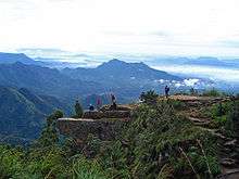
Panoramic view of Kodaikanal, 2008 | |
 Location in Tamil Nadu, India | |
| Coordinates: 10°14′N 77°29′E / 10.23°N 77.48°ECoordinates: 10°14′N 77°29′E / 10.23°N 77.48°E | |
| Country | India |
| State | Tamil Nadu |
| District | Dindigul |
| Established | 1845[1] |
| Government | |
| • Chairman | Thiru Sridhar |
| • Vice Chairman | Edward |
| Area | |
| • Total | 21.45 km2 (8.28 sq mi) |
| Elevation | 2,133 m (6,998 ft) |
| Population (2011) | |
| • Total | 36,501 |
| • Density | 1,100/km2 (3,000/sq mi) |
| Languages | |
| • Official | Tamil |
| Time zone | IST (UTC+5:30) |
| PIN | 624101 |
| Telephone code | 04542 |
| Vehicle registration | TN 57 |
| Nearest city | Madurai 121 km (75 mi) |
| Sex ratio | M 51% F 49% ♂/♀ |
| Literacy | 66% 1991% |
| Precipitation | 1,650 millimetres (65 in) |
| Avg. summer temperature | 19.8 °C (67.6 °F) |
| Avg. winter temperature | 8.3 °C (46.9 °F) |
| Website |
www |
| Website: Kodaikanal Municipality | |

Kodaikanal(தமிழ்:கொடைக்கானல்) is a city in the hills of the Dindigul district in the state of Tamil Nadu, India.[2] Its name in the Tamil language means "The Gift of the Forest".[3] Kodaikanal is referred to as the "Princess of Hill stations" and has a long history as a retreat and popular tourist destination.
Kodaikanal was established in 1845 as a refuge from the high temperatures and tropical diseases of the plains.[4] Much of the local economy is based on the hospitality industry serving tourism. As of 2011, the town had a population for 36,501.
Etymology
It is not known who first used this name or what they intended it to mean.
The word Kodaikanal is an amalgamation of two words: kodai and kanal. The Tamil language has at least four possible interpretations of the name Kodaikanal.
By pronouncing the first syllable of Kodaikanal with a long Tamil 'O', as in koe-dei, it means "summer", whilst the final two syllables kanal can mean "to see", rendering Kodaikanal as a "place to see in summer". Kodaikanal is a summer forest, and it is a place that the first missionaries used as a refuge to escape the overbearing and mosquito-ridden heat of the plains — a place that they would have counted on seeing in the summer!
Kanal, in Tamil, can mean dense or closed forest. In this case, Kodai can have at least four meanings. By pronouncing Kodai with the long Tamil 'O' and short 'e', Ko-dai means "the end". Kodaikanal could mean "the end of the forest" which makes poetic and geographical sense — Kodaikanal is at the crown of the Palani Hills and is effectively surrounded and protected by thick forests.[3]
By pronouncing Kodai with the short Tamil 'O' (as in Kodi), it means "creepers" or vines. Kodaikanal could mean "forest of creepers" or the forest of vines. "The forest of creepers" is thought to be the English language meaning given in 1885 during the early western habitation of the place[5] and is still accepted.[6]
By pronouncing Kodai with a short Tamil 'O', and a long 'E', it might be interpreted to mean "gift", rendering "Kodaikanal" as "gift of the forest". Keeping the short Tamil 'O' but adding a long 'A', Kodai could be understood as the Tamil word for umbrella, where Kodaikanal is a forest fashioned like a protecting umbrella. Or perhaps 'umbrella' just because of the once pristine shola, it rained so much in Kodai![3]
Another Tamil word for creeper or vine is valli, the honey collecting daughter of the chief of the Veddas mountain tribe. The chief and his wife prayed to the Mountain God for a girl and their prayers were answered when the chief found a newborn girl child during a hunting expedition. As she was found among creeper plants, they named her Valli and she grew up as princess of the tribe in Kurinji and became the consort of lord Murugan.[7] The romantic traditions of Murugan in Sangam literature are thus associated with the name Kodaikanal.
History
The earliest residents of Kodaikanal were the Palaiyar tribal people. The earliest specific references to Kodaikanal and the Palani Hills are found in Tamil Sangam literature of the early Common era.[8] Modern Kodaikanal was established by American Christian missionaries and British bureaucrats in 1845, as a refuge from the high temperatures and tropical diseases of the plains.[4] In the 20th century a few elite Indians came to realise the value of this enchanting hill station and started relocating here.[9]
Tourism has been impacted by industrial pollution issues including the closure of a mercury factory owned by Unilever's Indian subsidiary Hindustan Unilever after evidence of widespread mercury pollution.[10] To date no proper clean-up operation has been mounted. The issue gained prominence in early 2015 when "Kodaikanal Won't", a rap music about mercury pollution in the region went viral globally getting more than a million views in 4 days.
Geography

The town of Kodaikanal sits on a plateau above the southern escarpment of the upper Palani Hills at 2,133 metres (6,998 ft), between the Parappar and Gundar Valleys. These hills form the eastward spur of the Western Ghats on the Western side of South India. It has an irregular basin as its heartland, the centre of which is now Kodaikanal Lake a 5 kilometres (3.1 mi) circumference manmade lake. A few kilometers away from Kodaikanal a small village named Vattakanal is located in the Dindigul District on the southern tip of the upper Palani hills in the state of Tamil Nadu, along the eastern coast of the Western Ghats. Vattakanal is better known as 'Vatta' by most or 'Little Israel' by the villagers that observe a large number of Israeli tourists who flock there from October onwards.
Meadows and grasslands cover the hillsides. Gigantic Eucalyptus trees and shola forests flourish in the valleys. Mighty rocks and cascading streams lie above the valleys. There are many high waterfalls and ubiquitous gardens and flower beds in bloom.[9]
Kodaikanal is known for its rich flora. Of the big trees, cypress, eucalyptus and acacia are the dominant varieties. Pear trees are numerous and the fruits are of high quality. Competing with the fruit trees are the flowering ones - mainly rhododendron and magnolia. Large dahlias of different hues are the main attraction of Bryant Park, situated close to the Kodai lake. Water lilies in the park's pond are another pleasing sight. The town abounds in a kind of beautiful yellow wild flowers.[11]
North of the town, high hills that slope down into the villages of Pallangi and Vilpatti stand guard. On the east the hill slopes less abruptly into the lower Palnis. A precipitous escarpment facing the Cumbum Valley is on the south. On the west is a plateau leading to Manjampatti Valley, Indira Gandhi National Park, the Anamalai Hills and the main body of the Western Ghats of Kerala boarder.
Climate
Kodaikanal has a monsoon-influenced subtropical highland climate (Cfb/Cwb, according to the Köppen climate classification). The temperatures are cool throughout the year due to the high elevation of the city.
| Climate data for Kodaikanal | |||||||||||||
|---|---|---|---|---|---|---|---|---|---|---|---|---|---|
| Month | Jan | Feb | Mar | Apr | May | Jun | Jul | Aug | Sep | Oct | Nov | Dec | Year |
| Average high °C (°F) | 17.5 (63.5) |
18.6 (65.5) |
20.1 (68.2) |
20.6 (69.1) |
20.9 (69.6) |
18.9 (66) |
17.7 (63.9) |
17.9 (64.2) |
18.1 (64.6) |
17.4 (63.3) |
16.4 (61.5) |
16.7 (62.1) |
18.4 (65.13) |
| Average low °C (°F) | 8.1 (46.6) |
8.5 (47.3) |
10.1 (50.2) |
11.7 (53.1) |
12.6 (54.7) |
12.0 (53.6) |
11.4 (52.5) |
11.3 (52.3) |
11.2 (52.2) |
10.7 (51.3) |
9.7 (49.5) |
8.7 (47.7) |
10.5 (50.92) |
| Average precipitation mm (inches) | 59.1 (2.327) |
34.6 (1.362) |
52.6 (2.071) |
136.0 (5.354) |
146.1 (5.752) |
97.7 (3.846) |
122.1 (4.807) |
153.1 (6.028) |
185.6 (7.307) |
253.9 (9.996) |
235.0 (9.252) |
141.4 (5.567) |
1,617.2 (63.669) |
| Source: World Meteorological Organization.[12] | |||||||||||||
Demographics
According to the 2011 census, Kodaikanal had a population of 36,501 with a sex-ratio of 1,004 females for every 1,000 males, much above the national average of 929.[13] A total of 3,893 were under the age of six, constituting 1,945 males and 1,948 females. Scheduled Castes and Scheduled Tribes accounted for 19.86% and .28% of the population respectively. The average literacy of the city was 79.78%, compared to the national average of 72.99%.[13] The city had a total of : 9442 households. There were a total of 14,103 workers, comprising 163 cultivators, 744 main agricultural labourers, 130 in household industries, 12,118 other workers, 948 marginal workers, 10 marginal cultivators, 51 marginal agricultural labourers, 34 marginal workers in household industries and 853 other marginal workers.[14] As per the religious census of 2011, Kodaikanal had 48.84% Hindus, 12.0% Muslims, 38.69% Christians, 0.02% Sikhs, 0.22% Buddhists, 0.04% Jains, 0.15% following other religions and 0.04% following no religion or did not indicate any religious preference.[15]
Economy

| Season | Months |
| Peak Season | April–June |
| Low Season | Feb-March; July–September |
| Second Season | October–January |
The economy of Kodaikanal predominantly depends on tourism. The number of tourists increased from two million in 1999 to 3.2 million in 2009.[16] The town's infrastructure changes every year in preparation for the peak tourist season. Major roads are converted into one-way lanes to regulate the constant inflow of traffic and special police are brought in for the safety of the tourists and protection of local businesses. Hotels are often fully booked during the high season, and remain virtually empty during the off-season. Due to the rapid development of nearby cities such as Madurai and Coimbatore, the town is learning to deal with year-round tourism.
Plums, pears, chile peppers, carrots, cauliflower, cabbage, garlic and onions are cultivated by terrace farmers in surrounding villages. Most are trucked to other parts of India and some are sold in the local market. Popular tourist souvenirs include handcrafts, home-made chocolates, postcards and Eucalyptus oil.
Due to its relatively unpolluted image, various locations[17] within Kodaikanal are used for movie shootings as well. Some examples being Jo Jeeta Wohi Sikandar [18] though depicted as Dehradun, the Tamil movie Guna, Manmadhan Ambu, Thenali etc.
Health
The major medical facilities are KHMS Hospital, Van Allen Hospital and the Government Hospital and The Prana Spa. These hospitals treat patients with common ailments and injuries and perform child delivery and care, but are not equipped with modern medical equipment for complicated diagnoses and surgery.
KHMS hospital in 2009 was formed to provide quality health care to residents and visitors.
In April 1915, Dr. Van Allen raised funds to construct the first unit of the hospital at the entrance of Coaker's walk. It was named after him. Facilities got updated from time to time and now it has X-ray machine, well equipped pathological lab, and operation theatre with blood transfusion facilities.
The Government Hospital is situated on the hillside near Rock Cottage on Lower Shola Road. It was a small municipal hospital until 1927. Now it has X-ray, Dental, and Maternity wards and other facilities.
Kodaikanal Mercury Poisoning
Air and water-borne mercury emissions have contaminated large areas of Kodaikanal and the surrounding forests. A study conducted by the Department of Atomic Energy confirmed that Kodaikanal Lake has been contaminated by mercury emissions.,[19][20]
Mercury pollution was reported in Kodaikanal affecting lakes in the area. The causes, originating from a Hindustan Unilever thermometer factory nearby, were reported to be dispersal of elemental mercury into the atmosphere from improper storage and dispersal into the water from surface effluents from the factory. Apart from tests conducted on Kodaikanal lake, moss samples collected from trees surrounding the Berijam Lake, located 20 km (12.4 mi) from the factory were also tested. These showed mercury levels in the range of 0.2 µg/kg, while in Kodaikanal lake the lichen and moss levels were 7.9 µg/kg and 8.3 µg/kg, respectively. Fish samples taken from Kodaikanal lake also showed Hg levels in the range of 120 to 290 mg/kg confirming that pollution of the lake had taken place due to mercury emissions from the factory.[21]
The Hindustan Unilever thermometer factory caused widespread mercury pollution through improper disposal of broken thermometer waste containing large quantities of mercury. The factory sold much of this waste to a junkyard in Kodaikanal and also dumped large quantities in the forest behind the factory. The factory was eventually closed in 2001 after 18 years of operation. Hindustan Lever, have used considerable legal manoeuvering to avoid paying compensation to the ex-workers and their families, many of whom died or became physically handicapped as a result of mercury poisoning.[22][23]
The ex-workers joined to form the 559-strong Ex-Mercury Employees Welfare Association and in 2006 filed a Public Interest Litigation (PIL) suit in the Madras High Court. The association wants an economic rehabilitation scheme, healthcare treatment and a monitoring programme at the company's expense for everyone who ever worked in the factory. It also wants the company prosecuted. Hindustan Unilever denies that any of the health problems of the workers or their families were the result of mercury exposure in the factory. In 2010 the workers were still fighting for compensation.[24]
In June 2007, the Madras High Court constituted a five-member expert committee to decide on the mercury workers' health claims. The last court hearing was in June 2008. The committee later failed to find sufficient evidence to link the current clinical condition of the factory workers to past mercury exposure in the factory.[25]
In November 2011, a Ministry of Labour, Government of India commissioned report made the following observations to the Hon'ble Madras High Court:
"The committee is of the opinion that there is a prima-facie evidence from the personal & medical investigation of victims during the field visit to HLL Factory, Kodaikanal on 4th, 5th & 6th October, 2011 that not only the ex-workers of the HLL, Kodiakanal, but also their new born children have suffered on account of mercury exposure such as Tremor, knee pain, Loss of memory, Loss of teeth, Irregular menstrual period for women, Infertility, Skin problmes, Premature delivery of baby by pregnant women and children having ailments like Mental retardation, Deformity of organ, Birth defect like blue baby and Loss of memory were also noticed."
Additional site remediation studies are being undertaken by national institutions, as desired by the Tamil Nadu Pollution Control Board (TNPCB) and the Court's Scientific Experts Committee (SEC) during the project review meeting in January 2010. IIT Delhi is revalidating the risk assessment study and site-specific clean-up standards; the National Botanical Research Institute, Lucknow, is studying the impact on trees and preservation of trees; and the Centre for Soil and Water Conservation Research and Training Institute, Ooty, is studying the impact on soil and soil erosion. Based on the above study findings, results of remediation trials and recommendations of the SEC, the TNPCB will take a final decision on the clean-up standards. Hindustan Unilever Ltd. (HUL) will commence soil remediation work at the factory site once a decision on clean-up standards is taken and consent is given by TNPCB.[26]
Education
The following schools are located at Kodaikanal: R.C.Town Higher Secondary School, Pck Presentation Convent Primary School, Bhavan's Gandhi Vidyashram,[27] Brindavan Public School,[28] Kodaikanal International School, Kodaikanal Public School,[29] St. John's Girls Higher Secondary School, St. Joseph's Public School, St.Peter's Matriculation Higher Secondary School,[30] St. Xavier's High School, Zion Matriculation High School, Sankara Vidhyalaya.
The main colleges here are: Kodaikanal Christian College, which is the first Arts and Science College in Kodaikanal established in the year 1994; ever since, the college says, it has been committed to imparting holistic education and transforming students into model global leaders, for which the evidence is seen in the strong alumni. The American University of India (AUI) / Kodai International Business School (KIBS) (www.auiedu.com) is an elite Business school offering MBA & BBA programs in USA & India located in Ugarthenager. Sacred Heart College. Mother Theresas University is distinctive as India's only university exclusively devoted to women's issues.[31]
In 2005 a new engineering college specializing in Information Technology, Kodaikanal Institute of Technology under Anna University, was established 22 kilometres (14 mi) below Kodaikanal town.
Religion
Since Kodaikanal was founded by the American and European Missionaries, Christian churches are abundant. They include the Church of South India (opposite Bryant Park), St. Peters Church (near Coakers Walk), Gorapur, Lake End, La Salette, Lutheran Mission, Sacred Heart (Munjikal), Saint Antony's (Antonyar Kovil Street), Saint Francis Xavier, Saint Joseph's, Saint Mary's and Saint Peter's (Coakers Walk Road). Amongst the most popular is Union Church with a large Tamil congregation and Margaret Eddy Memorial Chapel at Kodai International School with lively services in a typically American style and distinctive stone architecture.
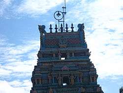
There are many Hindu Temples in Kodaikanal including the Durgai Amman Kovil, Kurinji Andavar Kovil, Mariamman Kovil, Observatory Murugan Kovil and Vinayagar Kovil. The Muslim mosques are Ellis Villa and Munjikal. There is an active community of Tibetan Buddhist refugees.
Civil Society
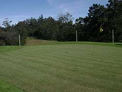
Kodaikanal has several clubs and civil society organizations operating for social, charitable and environmental goals. Established clubs in Kodaikanal are the Kodaikanal Lions Club (est. 1985) under the jurisdiction of Lions Clubs International (district 324B); Kodaikanal Boat Club (est. 1890) with nearly 650 permanent members; Kodaikanal Golf Club (est. 1895) with over 600 members and an 18-hole golf course, spread over 143 acres (0.58 km2); The Indian Club (est. 1915) on Poet Thyagarajar Road and The Rotary Club of Kodaikanal.[33]
In 1890, the Kodaikanal Missionary Union (KMU) was formed to enable missionaries of the various denominations to come together for recreation and to develop mission strategy and outreach in cooperation with each other. In 1923 it built an Edwardian style clubhouse with large central hall for social events and afternoon teas, 6 tennis courts, a reading room, and other spaces for meetings.[34] With the decline of missionary activity in India, the KMU was wound up in the 1980s, and the property was turned over to Kodaikanal International School. The KMU library with many valuable old books besides newer materials, is still functioning in one room, and provides something of a social venue. The valuable original KMU archives materials have been incorporated into the archives of the school, which has hired an archivist and is in process of converting the whole original KMU building into an archives and display centre for the school and the community.[35] (2008)

Kodaikanal has several Social service societies which promote local trade and increase employment of rural villagers in the town's periphery by participating in its tourism fuelled growth. These include the Kodaikanal People Development Group (KOPDEG) which has been successful in providing employment for marginalized women and marketing their products. The Made-in-India tagged products from Kopedeg are unique to Kodaikanal and are targeted at foreign tourists who regularly buy them as souvenirs.[36]
The Cottage Crafts Shop at Anna Salai, is run by the voluntary organisation, Coordinating Council for Social Concerns in Kodai (CORSOK). They sell goods crafted by development groups and uses the commission charged to help the needy.[37]
In 1994 the "Potter's Shed" was inaugurated. This pottery and craft Shop in Kodaikanal has made and sold hundreds of thousands of fine pieces of locally made pottery. All profits from this business are contributed to the Bethania Kids, Center For Children with Disabilities.[38]
The Kodaikanal Lake Protection Council and Vattakkanal Organization for Youth, Community and Environment (VOYCE) are active in preserving Kodaikanal's environment. Plastic bags are banned and almost all shops and roadside vendors heed the rule and use recycled paper bags in fear of a social reprisal. Local hotels have also participated in improving the environment by placing garbage cans all across the town, with their prominent donated by signs acting as silent salesmen.[39]
Places of Interest
Kodaikanal has several scenic natural attractions which are enjoyed by its visitors and make it a popular romantic destination for newlyweds. These are described in order of distance from the bus-stand.
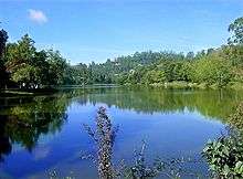
Kodaikanal Lake, is an artificial, roughly star-shaped 45 ha (60 acres) lake built in 1863. It is recognized as Kodaikanal's most popular geographic landmark and tourist attraction. Rowboats and pedalos can be hired at the Kodaikanal Boat Club. Horses and bicycles can be hired beside the lake for short periods. The 5 kilometres (3.1 mi) path that skirts the periphery of this lovely lake is a favourite walk for the locals and tourists alike.

Bryant Park: Just east of the lake and 500 metres (1,600 ft) from the bus stand, is a wonderfully maintained 20.5 acres (8.3 ha) botanical garden. The park was planned and built in 1908 by a forest officer from Madurai, H.D.Bryant, and named after him. With 325 species of trees, shrubs and cacti, the park is a rainbow of stunning flowers during the peak season. A large section is dedicated to nearly 740 varieties of roses. There is an 1857 Eucalyptus tree and a Bodhi tree which adds a religious significance to the park. Ornamental plants are cultivated in a nursery for sale. The park organizes horticultural exhibits and flower shows every summer, to coincide with the peak season. The entrance fee to the park is nominal, and it is open all year.[40]
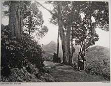
Coaker's Walk, 500 metres (1,600 ft) from the bus-stand, constructed by Lt.Coaker in 1872, is a 1-kilometre (3,300 ft) paved pedestrian path running along the edge of steep slopes on the southern side of Kodai. The walk, winding around Mount Nebo, starts in front of the Van Allen hospital, running parallel to the Van Allen Hospital Road and joins the main road beside St.Peter's Church, providing a stunning panoramic view of the plains. On a clear day one can view as far as Dolphin's Nose in the south, the valley of the Pambar River in the southeast, Periyakulam town and even the city of Madurai. A fascinating rare phenomenon called Brocken spectre can be witnessed, when a person can see his shadow on the clouds with a rainbow halo. This occurs when the sun is behind the viewer and clouds and mist are to the front. There is an observatory with a telescope halfway along the walk. Entrance fee to the walkway is nominal and it is open all year.
Bear Shola Falls, 3 kilometres (1.9 mi) from the bus-stand, is a tall waterfall in a Reserve forest. The final approach to this quiet area is a gently climbing foot-path.

Green Valley View, (formerly called Suicide Point) 5.5 kilometres (3.4 mi) from the bus-stand and near the golf course, has an excellent panoramic view of the plains and a sheer drop of 1,500 metres (4,900 ft) overlooking the Vaigai Dam to the south. The stairway leading up to it is highly commercialized and lined with rows of shops to tempt tourists.[41]
Pine forests, In 1906, with a view to growing valuable timber, Mr. Bryant started the Kodaikanal pine plantations in the south-west of Kodaikanal.[42]
Shembaganur Museum of Natural History, 6 kilometres (3.7 mi) from the bus-stand, founded in 1895, is open to the public (except Tuesdays) for viewing their outstanding taxidermy collection of more than 500 species of animals, birds and insects and a living collection of over 300 exotic orchid species. The museum is affiliated with Loyola College in Chennai and exhibits artifacts of the ancient Palaiyar tribes people whose descendants still live in these hills.[43]

Kodaikanal Solar Observatory, 6 kilometres (3.7 mi) from the bus-stand on Observatory Road, at 2,343 metres (7,687 ft) is the highest location near Kodai. The first observations were commenced here in 1901.[44] Former Director John Evershed discovered the phenomenon of radial motion in sunspots, now known as the Evershed effect. The Kodaikanal Terrestrial Telescope can view a grand panorama including: Sothupparai Dam, Vaigai Dam, Periyakulam and Varaha river. This Indian Institute of Astrophysics facility has a comprehensive Astronomical Science museum with organized public tours, access to the astronomy library, and scheduled night-time telescopic sky viewing. It is open daily to the public during peak season, and a few hours each Friday the rest of the year.[45]


Pillar Rocks, 8 kilometres (5.0 mi) from the bus-stand, is a set of three giant rock pillars which stand 122 metres (400 ft) high.[46] Managed by the Tamil Nadu Forest Department, The viewpoint can be crowded but is not commercialized. There is an excellent public garden adjacent to the viewpoint.
Guna caves,[47] made popular by the Tamil movie Guna, previously called Devil's Kitchen, are deep bat-infested chambers between the three gigantic boulders that are the Pillar Rocks. The deep narrow ravines of the caves are now closed to public due to the tragic deaths of twelve youths there.[48] These dangerous caves are highly protected now, and tourists can see sections of the cave system from afar.[49] In the late 1970s the inside of the caves was well photographed.
Silver Cascade, 8 kilometres (5.0 mi) from Kodaikanal at a wide bend in the long and winding Laws Ghat Road, at altitude 1,800 metres (5,900 ft), is a 55-metre (180 ft) waterfall formed from the outflow of Kodaikanal Lake.[50] The water quality is reportedly poor and not good enough for bathing.[51] This impressive waterfall is a popular stop for first-time visitors. There are a few souvenir and fruit vendors and many monkeys here. There is also a smaller but more serene waterfall below the bridge which crosses the stream here.
Dolphin's Nose, 8 kilometres (5.0 mi) from the bus stand, is flat rock projecting over a breathtaking chasm 6,600 feet (2,000 m) deep. It is an undisturbed area 1 kilometre (0.62 mi) down a very steep rocky trail beginning soon after Pambar Bridge. Orange juice vendors along the trail offer a welcome rest stop. Beautiful views of steep rocky escarpments rising from the plains can be seen. The old village of Vellagavi can be reached through a rugged bridle path here. A short paved walkway leads from the road here to Pambar falls (which is also locally addressed as 'Liril Falls' after the famous Liril Soap Advertisement filming in 1985).
Kurinji Andavar Murugan temple, 4 kilometres (2.5 mi) from the bus-stand, is famous for its Kurinji flower which blossoms in the area only once every 12 years. The deity here is called Sri Kurinji Easwaran, who is Lord Murugan. This temple was built in 1936 by a European lady, who on coming to Ceylon, converted to Hinduism.She changed her name to Leelavathi and married Mr.Ponnambalam Ramanathan. She is also known as Lady Ramanathan. This temple was handed over to Arulmighu Dhandayuthapani Swamy Thiru Kovil, Palani by Devi Prasad Bhaskaran (also known as Padmini, niece and adopted daughter of S Natesan Pillai, son in-law of Lady Ramanathan) and her husband R. Bhaskaran.
Berijam Lake is surrounded by nature at a distance of around 20 km from Kodaikanal. Boating is prohibited as the lake is a source of water for villages. Forest department permission is required and limited number of vehicles are allowed to enter the forest area where the lake is situated. Entry is restricted into the Berijam Lake area to between 9.30 a.m. and 3 p.m. Bison, deer, panthers and snakes are often spotted in this area. The fire tower, Silent Valley, Medicine Forest, and Lake View are other attractions around the lake. Psilocybin mushrooms which produce hallucinogenic effects when consumed, and other poisonous mushrooms grow around Berijam. Medicine Forest has a certain species of trees whose fragrance is believed to be having hallucinogenic effects. To enter into the Berijam Lake permission must be obtained from the Forest Department. Usually they give permission around 8 a.m. every day except on Tuesdays. They give permission to about 80 to 100 vehicles per day and collect the entry fee of around Rs.150 depending upon the vehicle.
Transport
Air
Almost all distances from Kodaikanal are calculated with the lake as the central point of reference.
The nearest airports are as follows:-
- Madurai (115 kilometres or 71 miles)
- Coimbatore (170 kilometres or 110 miles)
- Tiruchirapalli International Airport (197 kilometres or 122 miles)
- Tuticorin (262 kilometres or 163 miles)
Train
The nearest railway stations are Palani Station (64 kilometres or 40 miles) north,
Kodaikanal Road Station (80 kilometres or 50 miles) south east, Dindigul Junction (100 kilometres or 62 miles) east.[52]
Madurai Junction (114 kilometres or 71 miles) nearly east.[53]
Bus
From Madurai Aarappalayam bus stand, frequent bus services are available. Also bus available from Kodai road & Dindigul
The 2–3-hour drive to Kodaikanal via the steep and winding Ghat roads from Batlagundu or Palani is a memorable experience. Travellers may stop at turnouts on the road and enjoy the scenic beauty of the Palani hills.[54] There is a 28 km shortcut from Periyakulam to Kodaikanal via Kumbakarai. Bicycle rental, taxis, vans and limited city buses are available.[55] Auto rickshaws are not available.[56]
References
- ↑ Kodaikanal Department Of Municipal Administration And Water Supply, Historical Moments, 2005
- ↑ "Aringnar Anna Zoological Park". Tamilnadu.com. 8 February 2013.
- 1 2 3 "About City". Government of Tamil Nadu. Kodaikanal Department Of Municipal Administration And Water Supply. Retrieved 23 November 2009.
- 1 2 Mitchell Nora, Indian Hill Station: Kodaikanal, University of Chicago, Dept. of Geography, ch 2, Rational for Tropical Hill Sations, pp13-15, 1972. Original from the University of California Digitized 28 Jan 2008
- ↑ The Cyclopaedia of India and of Eastern and Southern Asia by Edward Balfour, Published by B. Quaritch, 1885, Item notes: vol.2 H-NYSA, P583, Original from the University of Michigan, Digitized 29 Jan 2008
- ↑ Mitchell Nora, Indian Hill Station: Kodaikanal, University of Chicago, Dept. of Geography, place creepers, p. 98, 1972. Original from the University of California, digitized 28 Jan 2008
- ↑ Sangam landscape#Kurinji .E2.80.93 Mountainous Region
- ↑ Mitchell Nora, Indian Hill Station: Kodaikanal, University of Chicago, Dept. of Geography, Kodaikanal Sangam, p97, 1972 Original from the University of California Digitized 28 Jan 2008
- 1 2 Tamil Nadu Tourism Development Corporation and Department of Tourism, Kodaikanal Princess of Hill Stations
- ↑ "Unilever Environmental Pollution". Corporate Watch. Retrieved 2007-08-08.
- ↑ The declining Kodai Frontline Magazine pgs 74-81, 26 May-Jun 8, 1989
- ↑
- 1 2 "Census Info 2011 Final population totals". Office of The Registrar General and Census Commissioner, Ministry of Home Affairs, Government of India. 2013. Retrieved 26 Jan 2014.
- ↑ "Census Info 2011 Final population totals - Kodaikanal". Office of The Registrar General and Census Commissioner, Ministry of Home Affairs, Government of India. 2013. Retrieved 26 Jan 2014.
- ↑ "Population By Religious Community - Tamil Nadu" (XLS). Office of The Registrar General and Census Commissioner, Ministry of Home Affairs, Government of India. 2011. Retrieved 13 September 2015.
- ↑ S. Molur; K.G. Smith; B.A. Daniel; W.R.T. Darwall, "Anon. 2011. Tourism in forest areas of Western Ghats. Equations, January 2001, Bangalore." (PDF), THE STATUS AND DISTRIBUTION OF FRESHWATER BIODIVERSITY IN THE WESTERN GHATS, INDIA, p. 82, retrieved 2011-09-26
- ↑ Filmapia.com, Movie Location > Kodaikanal
- ↑ Filmapia.com, Ratan's Town in Jo Jeeta Wohi Sikandar
- ↑ The Hindu, "Prevent mercury pollution", (2007-8-23),
- ↑ Studies of mercury pollution in a lake due to a thermometer factory situated in a tourist resort : Kodaikkanal, India, Author(s): KARUNASAGAR D. (1) ; BALARAMA KRISHNA M. V. (1) ; ANJANEYULU Y. (2) ; ARUNACHALAM J. (1) ; Author(s) Affiliation(s) (1) National Center for Compositional Characterization of Materials (CCCM), Bhabha Atomic Research Centre, Department of Atomic Energy, ECIL Post, Hyderabad 500 062, INDE, (2) Jawaharlal Nehru Technological University, Kukkatpally, Hyderabad, INDE Studies of mercury pollution
- ↑ D. Karunasagar; M.V. Balarama Krishna; Y. Anjaneyulu; J. Arunachalam (September 2006). "Studies of mercury pollution in a lake due to a thermometer factory situated in a tourist resort: Kodaikkanal, India" (PDF). Environmental Pollution. Elselvier. 143: 153–158. doi:10.1016/j.envpol.2005.10.032. Retrieved 2007-12-12.
- ↑ Rathnavelu R.; Amudhan R.P (7 November 2011), Mercury in the Mist, Chai Kadai U-Tube, retrieved 2011-12-09 External link in
|publisher=(help) - ↑ Chameleon Studio USA LLC (19 February 2011), Kodai vs Hindustan Lever press release.mp4, Greenpeace International, U-Tube, retrieved 2011-12-09
- ↑ Sarah Hiddleston (11 September 2010), "Poisoned Ground", The Hindu, Volume 27 - Issue 19, Kasturi & Sons Ltd
- ↑ "Kodaikanal, India", The Facts: Mercury contamination at our former thermometer factory, Kodaikanal, India; -Background, -Assessing the health of our workers, London: Unilever Global PLC, 2011, retrieved 2011-12-09
- ↑ Update on Progress of Environmental Issue of Erstwhile Kodaikanal Thermometer Factory in India (PDF), Mumbai: Hindustan Unilever Ltd., 2011, retrieved 2011-12-09
- ↑ Bhavan's Gandhi Vidyashram.
- ↑ Brindavan Public School.
- ↑ Kodaikanal Public School.
- ↑
- ↑ Theresa University
- ↑ http://www.thehindu.com/todays-paper/tp-features/tp-metroplus/honouring-the-kurinji/article7167847.ece
- ↑ http://www.dt3000internationalryla.info
- ↑ Heideman, Eugene P. From Mission to Church: The Reformed Church in America Mission to India, Wm. B. Eerdmans Publishing,"Kodaikanal Missionary Union" (KMU), p. 348 (2001) ISBN 0-8028-4900-8, ISBN 978-0-8028-4900-7 512 pages
- ↑ Kodaikanal International School, KIS Archives
- ↑ Kodaikanal People Development Group
- ↑ kodaikanal.com, Kodaikanal - Shopping
- ↑ Bethania Kids Potter's Shed, Kodaikanal
- ↑ R.W. Stewart and Tanya Balcar,Shola - Environmental Newsletter, The Anglade Institute of Natural History, Sacred Heart College, Shembaganur, Kodaikanal 624104, India, pp318-319, No. (26 December 2000) Environmental Information System - ENVIS : India, Pambar Shola : A Success Story in Conservation-V - Profit from Waste
- ↑ Kodaikanal Travel Guide, Bryant Park, 2007
- ↑ TripsGuru Travel Services, Switzerland of the East, Green Valley View
- ↑ Madras (India : State); B. S. Baliga (Rao Bahadur) (2002). Tamil Nadu district gazetteers. Printed by the Superintendent, Govt. Press. p. 166.
- ↑ NLC Ltd. (2004) "Important places -Kodaikanal" retrieved 4/12/2007 "Important places -Kodaikanal"
- ↑ Indian Institute of Astrophysics - A Brief History, Solar Observatory at Kodaikanal, retrieved 3/13/2007.
- ↑ Indian Institute of Astrophysics, Bangalore, Kodaikanal Observatory
- ↑ Tamil Nadu Tourism Development Corporation and Department of Tourism, "Kodaikanal-Princess of Hill Stations", p. 2
- ↑ Filmapia.com, Movie Location > Guna Cave (Devil's Kitchen)
- ↑ http://citypatriots.com/asia/india/tamil-nadu/kodaikanal/guna-cave
- ↑ Saravanan Ang Mo Kio, Life is 2 Alive, The Guna Cave - Devils Kitchen (2006-10-9)
- ↑ , By Indian Academy of Sciences, Published by Indian Academy of Sciences (1972) Item notes: v.76 1972 Jul-Dec, Original from the University of Michigan, Digitized 12 Apr 2006, Proceedings of the Indian Academy of Sciences, p. 126
- ↑ TripsGuru Travel Services, Switzerland of the East, Silver Cascade
- ↑ Kodaionline, Kodaikanal Travel Mode, 2008
- ↑ http://distancebetween2.com/, Kodaikanal Travel Mode 2015
- ↑ Dindugal District Collectors Office, retrieved 4/12/2007 About Dindugal District
- ↑ Kodai Travel Guide,Kodaikanal a Beautiful Hill Resort
- ↑ NLC Ltd., Important places around Neyveli Kodaikanal
Further reading
- Charlotte Chandler Wyckoff: Kodaikanal: 1845-1945. London Mission Press, Nagercoil, Travancore, Indien. 1945.
- Nora Mitchell: The Indian Hill Station Kodaikanal. Research paper, University of Chicago, Department of Geography, No. 141. Chicago Ill., 1972.
- Volker Winkler: Kodaikanal. Land of the Clouds. Hillsboro Press, Franklin (Tennessee) 1999.
External links
| Wikimedia Commons has media related to Kodaikanal. |
 "Kodaikanal". Encyclopædia Britannica. 15 (11th ed.). 1911.
| Wikivoyage has a travel guide for Kodaikanal. |
| State symbols |
|
|---|---|
| Governance |
|
| Topics | |
| Districts |
|
| Major cities | |