Owensboro, Kentucky metropolitan area
| Owensboro Metro, Tri-State Area | |
|---|---|
| Owensboro, KY (- IN) Metropolitan Statistical Area | |
 | |
| Country | United States |
| State(s) | Kentucky |
| Largest city | Owensboro |
| Other cities |
- Hawesville - Lewisport - Livermore - Calhoun - Sacramento - Island - Whitesville |
| Area | |
| • Total | 931 sq mi (2,410 km2) |
| Highest elevation | 580 ft (175 m) |
| Lowest elevation | 355 ft (109 m) |
| Population | |
| • Total | 114,752 (2,010) |
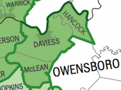
The Owensboro Metropolitan Statistical Area, as defined by the United States Census Bureau, is an area consisting of three counties in Kentucky, anchored by the city of Owensboro. As of the 2000 census, the MSA had a population of 109,875. In the 2010 Census the population was 114,752. Owensboro is part of the Illinois-Indiana-Kentucky tri-state area and sometimes referred to as Kentuckiana.
Possibilities for expansion and combination
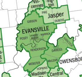
There is a chance that the Owensboro and Evansville Metros could eventually become the Evansville-Owensboro, IL-IN-KY Combined Statistical Area. In recent years, travel time has decreased and interaction has increased with improved infrastructure between the two areas and many of the micropolitan areas to the north and south like the new U.S. 231 Corridor and the expansion of the 6-lane Lloyd Expressway as well as the interaction between Owensboro and Henderson along the Audubon Parkway. The two areas have long been a single television market. As such, the area, along with the neighboring Evansville Area both make up significant parts of the Illinois-Indiana-Kentucky Tri-State Area, the main market definition for the area.
Counties
Communities
Incorporated places
- Calhoun
- Hawesville
- Island
- Lewisport
- Livermore
- Owensboro (Principal city)
- Sacramento
- Whitesville
Census-designated places
Note: census-designated places are unincorporated.
Demographics
As of the census[1] of 2000, there were 109,875 people, 43,232 households, and 30,142 families residing within the MSA. The racial makeup of the MSA was 94.46% White, 3.72% African American, 0.15% Native American, 0.37% Asian, 0.02% Pacific Islander, 0.41% from other races, and 0.87% from two or more races. Hispanic or Latino of any race were 0.90% of the population.
The median income for a household in the MSA was $34,467, and the median income for a family was $41,240. Males had a median income of $33,012 versus $21,659 for females. The per capita income for the MSA was $17,136.
See also
- Illinois-Indiana-Kentucky Tri-State Area
- Evansville, IN–KY Metropolitan Statistical Area
- Kentucky census statistical areas
References
- ↑ "American FactFinder". United States Census Bureau. Retrieved 2008-01-31.
