Fayette County, Kentucky
| Fayette County, Kentucky | |
|---|---|
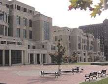 Robert F. Stephens Courthouse Complex in Lexington | |
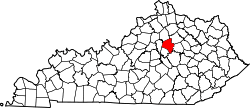 Location in the U.S. state of Kentucky | |
 Kentucky's location in the U.S. | |
| Founded | 1780 |
| Named for | Gilbert du Motier, Marquis de Lafayette |
| Seat | Lexington |
| Largest city | Lexington |
| Area | |
| • Total | 286 sq mi (741 km2) |
| • Land | 284 sq mi (736 km2) |
| • Water | 1.9 sq mi (5 km2), 0.7% |
| Population (est.) | |
| • (2015) | 314,488 |
| • Density | 1,087/sq mi (420/km²) |
| Congressional district | 6th |
| Time zone | Eastern: UTC-5/-4 |
| Website |
www |
Fayette County is a county located in the U.S. Commonwealth of Kentucky. As of the 2010 census, the population was 295,803,[1] making it the second-most populous county in Kentucky. Its territory, population and government are coextensive with the city of Lexington, which also serves as county seat.[2]
Fayette County is part of the Lexington–Fayette, KY Metropolitan Statistical Area.
History
Fayette County was one of the original three counties created from the former Kentucky County, Virginia, by the Virginia Act in 1780, along with Jefferson and Lincoln counties. Together they separated from Virginia in 1792 to become the Commonwealth of Kentucky.
Originally, Fayette County included land which makes up 37 present-day counties and portions of 7 others. It was reduced to its present boundaries in 1799. The county is named for the Marquis de LaFayette, who came to America to join the rebelling English colonies in the American Revolutionary War.[3][4]
On January 1, 1974, Fayette County merged its government with that of its county seat of Lexington, creating a consolidated city-county governed by the Lexington-Fayette Urban County Government.
Geography

According to the U.S. Census Bureau, the county has a total area of 286 square miles (740 km2), of which 284 square miles (740 km2) is land and 1.9 square miles (4.9 km2) (0.7%) is water.[5]
Major highways
Adjacent counties
- Scott County (north)
- Bourbon County (northeast)
- Clark County (east)
- Madison County (south)
- Jessamine County (south)
- Woodford County (west)
Demographics
| Historical population | |||
|---|---|---|---|
| Census | Pop. | %± | |
| 1790 | 18,410 | — | |
| 1800 | 14,028 | −23.8% | |
| 1810 | 21,370 | 52.3% | |
| 1820 | 23,250 | 8.8% | |
| 1830 | 25,098 | 7.9% | |
| 1840 | 22,194 | −11.6% | |
| 1850 | 22,735 | 2.4% | |
| 1860 | 22,599 | −0.6% | |
| 1870 | 26,656 | 18.0% | |
| 1880 | 29,023 | 8.9% | |
| 1890 | 35,698 | 23.0% | |
| 1900 | 42,071 | 17.9% | |
| 1910 | 47,715 | 13.4% | |
| 1920 | 54,664 | 14.6% | |
| 1930 | 68,543 | 25.4% | |
| 1940 | 78,899 | 15.1% | |
| 1950 | 100,746 | 27.7% | |
| 1960 | 131,906 | 30.9% | |
| 1970 | 174,323 | 32.2% | |
| 1980 | 204,165 | 17.1% | |
| 1990 | 225,366 | 10.4% | |
| 2000 | 260,512 | 15.6% | |
| 2010 | 295,803 | 13.5% | |
| Est. 2015 | 314,488 | [6] | 6.3% |
| U.S. Decennial Census[7] 1790-1960[8] 1900-1990[9] 1990-2000[10] 2010-2013[1] | |||
As of the census[11] of 2000, there were 260,512 people, 108,288 households, and 62,915 families residing in the county. The population density was 916 people per square mile (354/km²). There were 116,167 housing units at an average density of 408 per square mile (158/km²). The racial makeup of the county was 81.04% White, 13.48% Black or African American, 0.19% Native American, 2.46% Asian, 0.03% Pacific Islander, 1.21% from other races, and 1.58% from two or more races. 3.29% of the population were Hispanic or Latino of any race.
There were 108,288 households out of which 27.30% had children under the age of 18 living with them, 43.50% were married couples living together, 11.50% had a female householder with no husband present, and 41.90% were non-families. 31.70% of all households were made up of individuals and 7.50% had someone living alone who was 65 years of age or older. The average household size was 2.29 and the average family size was 2.90.
In the county the population was spread out with 21.30% under the age of 18, 14.60% from 18 to 24, 33.20% from 25 to 44, 20.90% from 45 to 64, and 10.00% who were 65 years of age or older. The median age was 33 years. For every 100 females there were 96.50 males. For every 100 females age 18 and over, there were 94.30 males.
The median income for a household in the county was $39,813, and the median income for a family was $53,264. Males had a median income of $36,166 versus $26,964 for females. The per capita income for the county was $23,109. About 8.20% of families and 12.90% of the population were below the poverty line, including 14.30% of those under age 18 and 8.60% of those age 65 or over.
Education
Public high schools
Schools in the county are operated by Fayette County Public Schools.
- Henry Clay High School
- Paul Laurence Dunbar High School
- Bryan Station High School
- Lafayette High School
- Tates Creek High School
Private middle and elementary schools
- The Lexington School
- Sayre School
- Lexington Christian Academy
- Christ the King School
- Saints Peter and Paul School
- Seton Catholic School
- Blue Grass Baptist School
- Redwood Cooperative School
Private high schools
- Lexington Catholic High School
- Lexington Christian Academy
- Sayre School
- Trinity Christian Academy
- Blue Grass Baptist School
Colleges and universities
- Bluegrass Community and Technical College
- Indiana Wesleyan University (Lexington campus)
- ITT Technical Institute
- Lexington Theological Seminary
- Midway College (Lexington campus)[12]
- National College of Business & Technology
- Spencerian College
- Sullivan University
- Transylvania University
- University of Kentucky
Communities
City
Unincorporated communities
- Andover
- Athens
- Clays Ferry
- Colby (partly in Clark County)
- Little Texas
- South Elkhorn
- Spears (partly in Jessamine County)
- Todds Station
Historically black hamlets
- Bracktown
- Cadentown
- Jimtown
- Smithtown
- Little Georgetown
- Pralltown
See also
References
- 1 2 "State & County QuickFacts". United States Census Bureau. Retrieved August 14, 2014.
- ↑ "Find a County". National Association of Counties. Archived from the original on May 10, 2015. Retrieved 2011-06-07.
- ↑ The Register of the Kentucky State Historical Society, Volume 1. Kentucky State Historical Society. 1903. p. 35.
- ↑ Gannett, Henry (1905). The Origin of Certain Place Names in the United States. Govt. Print. Off. p. 124.
- ↑ "2010 Census Gazetteer Files". United States Census Bureau. August 22, 2012. Retrieved August 14, 2014.
- ↑ "County Totals Dataset: Population, Population Change and Estimated Components of Population Change: April 1, 2010 to July 1, 2015". Retrieved July 2, 2016.
- ↑ "U.S. Decennial Census". United States Census Bureau. Archived from the original on May 11, 2015. Retrieved August 14, 2014.
- ↑ "Historical Census Browser". University of Virginia Library. Retrieved August 14, 2014.
- ↑ "Population of Counties by Decennial Census: 1900 to 1990". United States Census Bureau. Retrieved August 14, 2014.
- ↑ "Census 2000 PHC-T-4. Ranking Tables for Counties: 1990 and 2000" (PDF). United States Census Bureau. Retrieved August 14, 2014.
- ↑ "American FactFinder". United States Census Bureau. Retrieved 2008-01-31.
- ↑ "Midway College - Lexington Campus". Retrieved May 13, 2011.
External links
| Wikimedia Commons has media related to Fayette County, Kentucky. |
- Kentucky State Data Center
- Lexington Area Metropolitan Planning Organization
- Lexington-Fayette Urban County Government
- Fayette County Prosecutor's Office
- Fayette County Sheriff's Office
| Central city | 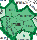 | |
|---|---|---|
| Municipalities with population over 10,000 | ||
| Municipalities with population 5,000-10,000 | ||
| Municipalities with population under 5,000 | ||
| Counties | ||

Coordinates: 38°02′N 84°28′W / 38.04°N 84.46°W