Rowan County, Kentucky
| Rowan County, Kentucky | |
|---|---|
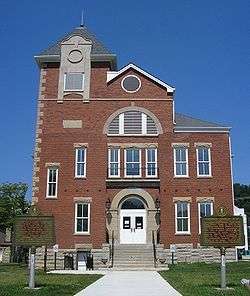 Rowan County Arts Center (formerly Rowan County Courthouse) in Morehead | |
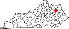 Location in the U.S. state of Kentucky | |
 Kentucky's location in the U.S. | |
| Founded | 1856 |
| Named for | John Rowan |
| Seat | Morehead |
| Largest city | Morehead |
| Area | |
| • Total | 286 sq mi (741 km2) |
| • Land | 280 sq mi (725 km2) |
| • Water | 6.5 sq mi (17 km2), 2.3% |
| Population | |
| • (2010) | 23,333 |
| • Density | 83/sq mi (32/km²) |
| Congressional district | 5th |
| Time zone | Eastern: UTC-5/-4 |
| Website |
www.moreheadrowan.org /rowancounty |
Rowan County (/ˈraʊ.ᵻn/) is a county located in the U.S. state of Kentucky. As of the 2010 census, the population was 23,333.[1] Its county seat is Morehead.[2] The county was created in 1856 from parts of Fleming and Morgan counties, and named after John Rowan, who represented Kentucky in the U.S. House and Senate.[3]
With regard to the sale of alcohol, it is classified as a moist county—a county in which alcohol sales are prohibited (a dry county), but containing a "wet" city, in this case Morehead, where package alcohol sales are allowed.[4]
History
It is believed that Rowan County was first explored in 1773 by a party of surveyors from Pennsylvania. The first settlement was established in Farmers, a town 10 miles west of Morehead. Its population rapidly increased due its fertile farming land and proximity to water sources. Additional settlers came to Rowan County from Virginia in the late 18th century after being awarded land grants at the end of the American Revolutionary War. Clearfield was the second settlement established in the county, being colonized by a Virginia aristocrat named Dixon Clack in the early 1800s. It accommodated the first sawmill in the county.[5]
In 1854, Morehead became the third community to be settled in the area.[6] Colonel John Hargis founded the city after purchasing land in the county, naming it after governor James Morehead.[7] Rowan County came into existence in May 1856, seceding from Morgan County and Fleming County. It was divided into four districts with Morehead being declared the county seat.[8] In 1896, a tax was levied on Morehead, sourcing it with the revenue needed to construct hard surface roads. The road system was extended to Farmers by 1920.[5]
In the summer of 2015, Rowan County attracted national attention when County Clerk Kim Davis refused, on grounds of religion, to follow a court order requiring her to issue marriage licenses to same-sex couples.[9]
Geography
According to the U.S. Census Bureau, the county has a total area of 286 square miles (740 km2), of which 280 square miles (730 km2) is land and 6.5 square miles (17 km2) (2.3%) is water.[10] Its highest point is "Limestone Knob" at about 1,409 feet (429 m) above mean sea level.
Adjacent counties
- Lewis County (north)
- Carter County (northeast)
- Elliott County (east)
- Morgan County (south)
- Menifee County (southwest)
- Bath County (west)
- Fleming County (northwest)
National protected area
- Daniel Boone National Forest (part)
Demographics
| Historical population | |||
|---|---|---|---|
| Census | Pop. | %± | |
| 1860 | 2,282 | — | |
| 1870 | 2,991 | 31.1% | |
| 1880 | 4,420 | 47.8% | |
| 1890 | 6,129 | 38.7% | |
| 1900 | 8,277 | 35.0% | |
| 1910 | 9,438 | 14.0% | |
| 1920 | 9,467 | 0.3% | |
| 1930 | 10,893 | 15.1% | |
| 1940 | 12,734 | 16.9% | |
| 1950 | 12,708 | −0.2% | |
| 1960 | 12,808 | 0.8% | |
| 1970 | 17,010 | 32.8% | |
| 1980 | 19,049 | 12.0% | |
| 1990 | 20,353 | 6.8% | |
| 2000 | 22,094 | 8.6% | |
| 2010 | 23,333 | 5.6% | |
| Est. 2015 | 23,892 | [11] | 2.4% |
| U.S. Decennial Census[12] 1790–1960[13] 1900–1990[14] 1990–2000[15] 2010–2013[1] | |||
As of the census[16] of 2010, there were 23,333 people, and 7,956 households residing in the county. The population density was 83.4 per square mile (32.2/km2). There were 10,102 housing units at an average density of 34 per square mile (13/km2). The racial makeup of the county was 96.1% White, 1.5% Black or African American, 0.1% Native American, 0.8% Asian, 0% Pacific Islander, and 1.0% from two or more races. 1.3% of the population were Hispanic or Latino of any race.
There were 7,956 households out of which 19.6% had children under the age of 18 living with them, 52.40% were married couples living together, 10.20% had a female householder with no husband present, and 34.20% were non-families. 27.00% of all households were made up of individuals and 9.20% had someone living alone who was 65 years of age or older. The average household size was 2.39 and the average family size was 2.91.
The age distribution was 20.30% under the age of 18, 23.50% from 18 to 24, 25.90% from 25 to 44, 20.00% from 45 to 64, and 10.40% who were 65 years of age or older. The median age was 30 years. Both the unusually large portion of the population in the 18-to-24 range and the relatively low median age are mainly because of the presence of Morehead State University. For every 100 females there were 94.60 males. For every 100 females age 18 and over, there were 93.10 males.
The median income for a household in the county was $33,081. Males had a median income of $26,777 versus $20,104 for females. The per capita income for the county was $13,888. About 15.90% of families and 21.30% of the population were below the poverty line, including 20.80% of those under age 18 and 16.20% of those age 65 or over.
As of 2014, the county had 14,263 registered voters.[17] Of these, 9,394 were Democrats, 3,929 were Republicans, and 626 listed themselves as members of other parties.[17]
Politics
Rowan County is known as a swing county. It went Republican in 2000, 2012, and 2016, and Democratic in 2004 and 2008, but in all those elections the winning candidate won by small margins.
| Year | Republican | Democrat |
|---|---|---|
| 2016 | 58.48% 5,174 | 37.24% 3,295 |
| 2012 | 52.64% 4,035 | 44.85% 3,438 |
| 2008 | 47.92% 3,907 | 49.96% 4,074 |
| 2004 | 46.67% 4,063 | 52.33% 4,556 |
| 2000 | 49.07% 3,546 | 48.51% 3,505 |
Media
- Rowan County – Official Site
- The Morehead News – Local Paper
- WMKY – Morehead State University Radio
- W10BM LP TV
- Rowan Review – Local Online News
Communities
Cities
- Lakeview Heights
- Morehead (county seat)
Unincorporated communities
- Clearfield
- Cranston
- Elliottville
- Farmers
- Gates
- Haldeman
- Hayes Crossing
- Hilda
- Paragon
- Pelfrey
- Rodburn
- Sharkey
- Smile
- Triplett
- Wagner Corner
See also
References
- Specific
- 1 2 "State & County QuickFacts". United States Census Bureau. Retrieved March 6, 2014.
- ↑ "Find a County". National Association of Counties. Retrieved 2011-06-07.
- ↑ The Register of the Kentucky State Historical Society, Volume 1. Kentucky State Historical Society. 1903. p. 36.
- ↑ "Wet & Dry Counties in Kentucky" (PDF). Kentucky Office of Alcoholic Beverage Control. Archived from the original (PDF) on March 15, 2007. Retrieved March 21, 2007.
- 1 2 "Farmers Once Industrial Center Of Rowan County". The Morehead News. 2 February 1977. Retrieved 26 February 2015.
- ↑ Thompson, George E. (2009). You Live Where?: Interesting and unusual facts about where we live. iUniverse. p. 236. ISBN 978-1440134210.
- ↑ Pearce, John Ed (2010). Days of Darkness: The Feuds of Eastern Kentucky. The University Press of Kentucky. ISBN 978-0813126579.
- ↑ "Early history of Rowan County as taken from the records of the first established womens club here". The Rowan County News. 30 April 1936. Retrieved 26 February 2015.
- ↑ "Kentucky Clerk Denies Same-Sex Marriage Licenses, Defying Court". New York Times. September 1, 2015. Retrieved September 1, 2015.
- ↑ "2010 Census Gazetteer Files". United States Census Bureau. August 22, 2012. Retrieved August 19, 2014.
- ↑ "County Totals Dataset: Population, Population Change and Estimated Components of Population Change: April 1, 2010 to July 1, 2015". Retrieved July 2, 2016.
- ↑ "U.S. Decennial Census". United States Census Bureau. Retrieved August 19, 2014.
- ↑ "Historical Census Browser". University of Virginia Library. Retrieved August 19, 2014.
- ↑ "Population of Counties by Decennial Census: 1900 to 1990". United States Census Bureau. Retrieved August 19, 2014.
- ↑ "Census 2000 PHC-T-4. Ranking Tables for Counties: 1990 and 2000" (PDF). United States Census Bureau. Retrieved August 19, 2014.
- ↑ "American FactFinder". United States Census Bureau. Retrieved 2008-01-31.
- 1 2 "Voter turnout expected to be high". Morehead News. Morehead, Kentucky. October 31, 2014.
- ↑ "Dave Leip's Atlas of U.S. Presidential Elections". Retrieved 2016-04-26.
- General
External links
Municipalities and communities of Rowan County, Kentucky, United States | ||
|---|---|---|
| Cities | | |
| CDP |
| |
| Other unincorporated communities | ||

Coordinates: 38°11′N 83°25′W / 38.19°N 83.42°W