Clinton County, Kentucky
| Clinton County, Kentucky | |
|---|---|
 Clinton County courthouse in Albany | |
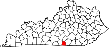 Location in the U.S. state of Kentucky | |
 Kentucky's location in the U.S. | |
| Founded | February 20, 1835 |
| Named for | DeWitt Clinton |
| Seat | Albany |
| Largest city | Albany |
| Area | |
| • Total | 205 sq mi (531 km2) |
| • Land | 197 sq mi (510 km2) |
| • Water | 8.2 sq mi (21 km2), 4.0% |
| Population | |
| • (2010) | 10,272 |
| • Density | 52/sq mi (20/km²) |
| Congressional district | 1st |
| Time zone | Central: UTC-6/-5 |
| Website |
clintoncounty |
Clinton County is a county located in the U.S. state of Kentucky. As of the 2010 census, the population was 10,272.[1] Its county seat is Albany.[2] The county was formed in 1835 and named for DeWitt Clinton, the seventh Governor of New York.[3] It is a prohibition or dry county.
History
Clinton County was formed on February 20, 1835 from portions of Cumberland and Wayne counties. It was named for DeWitt Clinton, governor of New York and driving force behind the Erie Canal.[4]
Courthouse fires in 1864 and 1980 resulted in the destruction of county records.[5]
Geography
According to the U.S. Census Bureau, the county has a total area of 205 square miles (530 km2), of which 197 square miles (510 km2) is land and 8.2 square miles (21 km2) (4.0%) is water.[6]
Adjacent counties
- Russell County (north)
- Wayne County (east/EST Border)
- Pickett County, Tennessee (south)
- Clay County, Tennessee (southwest)
- Cumberland County (west)
Demographics
| Historical population | |||
|---|---|---|---|
| Census | Pop. | %± | |
| 1840 | 3,863 | — | |
| 1850 | 4,889 | 26.6% | |
| 1860 | 5,781 | 18.2% | |
| 1870 | 6,497 | 12.4% | |
| 1880 | 7,212 | 11.0% | |
| 1890 | 7,047 | −2.3% | |
| 1900 | 7,871 | 11.7% | |
| 1910 | 8,153 | 3.6% | |
| 1920 | 8,589 | 5.3% | |
| 1930 | 9,004 | 4.8% | |
| 1940 | 10,279 | 14.2% | |
| 1950 | 10,650 | 3.6% | |
| 1960 | 8,886 | −16.6% | |
| 1970 | 8,174 | −8.0% | |
| 1980 | 9,321 | 14.0% | |
| 1990 | 9,135 | −2.0% | |
| 2000 | 9,634 | 5.5% | |
| 2010 | 10,272 | 6.6% | |
| Est. 2015 | 10,174 | [7] | −1.0% |
| U.S. Decennial Census[8] 1790-1960[9] 1900-1990[10] 1990-2000[11] 2010-2013[1] | |||
As of the census[12] of 2000, there were 9,634 people, 4,086 households, and 2,811 families residing in the county. The population density was 49 per square mile (19/km2). There were 4,888 housing units at an average density of 25 per square mile (9.7/km2). The racial makeup of the county was 99.09% White, 0.10% Black or African American, 0.25% Native American, 0.04% Asian, 0.11% Pacific Islander, 0.08% from other races, and 0.32% from two or more races. 1.22% of the population were Hispanic or Latino of any race.
There were 4,086 households out of which 29.80% had children under the age of 18 living with them, 55.50% were married couples living together, 9.70% had a female householder with no husband present, and 31.20% were non-families. 28.40% of all households were made up of individuals and 12.80% had someone living alone who was 65 years of age or older. The average household size was 2.34 and the average family size was 2.85.
In the county the population was spread out with 22.70% under the age of 18, 8.60% from 18 to 24, 27.70% from 25 to 44, 26.00% from 45 to 64, and 15.00% who were 65 years of age or older. The median age was 39 years. For every 100 females there were 92.90 males. For every 100 females age 18 and over, there were 91.50 males.
The median income for a household in the county was $19,563, and the median income for a family was $25,919. Males had a median income of $21,193 versus $16,194 for females. The per capita income for the county was $13,286. About 20.20% of families and 25.80% of the population were below the poverty line, including 31.80% of those under age 18 and 29.90% of those age 65 or over.
Communities
See also
- Garlin Murl Conner
- Dry counties
- National Register of Historic Places listings in Clinton County, Kentucky
References
- 1 2 "State & County QuickFacts". United States Census Bureau. Retrieved March 6, 2014.
- ↑ "Find a County". National Association of Counties. Archived from the original on 2011-05-31. Retrieved 2011-06-07.
- ↑ "Clinton County". The Kentucky Encyclopedia. 2000. Retrieved August 21, 2014.
- ↑ The Register of the Kentucky State Historical Society, Volume 1. Kentucky State Historical Society. 1903. p. 34.
- ↑ Hogan, Roseann Reinemuth (1992). Kentucky Ancestry: A Guide to Genealogical and Historical Research. Ancestry Publishing. p. 219. Retrieved 26 July 2013.
- ↑ "2010 Census Gazetteer Files". United States Census Bureau. August 22, 2012. Retrieved August 13, 2014.
- ↑ "County Totals Dataset: Population, Population Change and Estimated Components of Population Change: April 1, 2010 to July 1, 2015". Retrieved July 2, 2016.
- ↑ "U.S. Decennial Census". United States Census Bureau. Archived from the original on May 11, 2015. Retrieved August 13, 2014.
- ↑ "Historical Census Browser". University of Virginia Library. Retrieved August 13, 2014.
- ↑ "Population of Counties by Decennial Census: 1900 to 1990". United States Census Bureau. Retrieved August 13, 2014.
- ↑ "Census 2000 PHC-T-4. Ranking Tables for Counties: 1990 and 2000" (PDF). United States Census Bureau. Retrieved August 13, 2014.
- ↑ "American FactFinder". United States Census Bureau. Archived from the original on 2013-09-11. Retrieved 2008-01-31.
External links
Municipalities and communities of Clinton County, Kentucky, United States | ||
|---|---|---|
| City | | |
| Unincorporated communities | ||
| Footnotes | ‡This populated place also has portions in an adjacent county or counties | |

Coordinates: 36°43′N 85°08′W / 36.72°N 85.13°W