Todd County, Kentucky
| Todd County, Kentucky | |
|---|---|
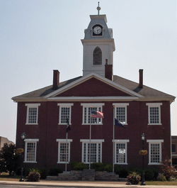 Todd County Courthouse | |
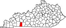 Location in the U.S. state of Kentucky | |
 Kentucky's location in the U.S. | |
| Founded | 1820 |
| Named for | Colonel John Todd |
| Seat | Elkton |
| Largest city | Elkton |
| Area | |
| • Total | 377 sq mi (976 km2) |
| • Land | 374 sq mi (969 km2) |
| • Water | 2.6 sq mi (7 km2), 0.7% |
| Population | |
| • (2010) | 12,460 |
| • Density | 33/sq mi (13/km²) |
| Congressional district | 1st |
| Time zone | Central: UTC-6/-5 |
| Website |
www |
Todd County is a county located in the U.S. state of Kentucky. As of the 2010 census, the population was 12,460.[1] Its county seat is Elkton.[2] The county is named for Colonel John Todd, who was killed at the Battle of Blue Licks in 1782 during the American Revolution.[3][4]
History
Early history
Todd County consists of two geographical regions known historically as the high country to the north and low country to the south. The northern highlands consist of steep-sloped sandstone terrain with forests of oak, walnut and poplar. The landscape contains steep bluffs and sharp rises and falls within the terrain. The southern lowlands consist of rolling limestone flatlands void of aquifer sinks and consist of dense but sparse forests of oak, walnut poplar and ash.[5] The historic inhabitants of the region before European encounter were the Iroquoian language-speaking Cherokee, who had migrated centuries earlier from areas around the Great Lakes. They used the lands for hunting and gathering.[6]
Todd County lies within what was originally considered the western portion of the Commonwealth of Virginia. Many of the original European-American settlers came when the area was still considered part of Virginia. This part of southern Kentucky was designated to be awarded to Virginia veterans of the American Revolutionary War as payment for their services.[7]
Justinian Cartwright was possibly the earliest United States settler to take up residence in what would become Todd County. However, the first proven migrants are Edward Shanklin Jr., Matthew and David Rolston, John Huston and his sons James and Granville Huston.[8] Samuel Davis, father of Jefferson Davis, and John Wilson were also early settlers of the county. Kentucky Governor Greenup made the first Kentucky land grants to veterans William Croghan, David Logan, Edward Shanklin Jr., and John Wilson, among others.[6]
Portions of Christian and Logan counties were taken to organize Todd County. Their more distant populations had demanded "home government," as travel to the county seats of Logan and Christian was arduous. The county was formed in 1820 by the first magisterial court, consisting of members Edward Shanklin, Major John Gray, Robert Coleman, Henry Gorin, John Taylor, H. C. Ewing, John S Anderson, William Hopper, John Mann and Joseph Frazer.[9] The petition was created and the legislature of the Commonwealth of Kentucky granted the act of legislature, enacting the creation of the county on April 1, 1820. The legislature designated that the county be named for Colonel John Todd, a native of Virginia and Robertson County, Kentucky, who died at the Battle of Blue Licks near Lexington. Colonel John Todd died in 1782, 38 years before the formation of Todd County.[6]
Development
Agriculture is a revered tradition in Todd County. The lowlands are of the finest rich soil types, including "Pembroke" soil. The lowlands are prized for their high growth yields. In the early 19th century, Major John Gray established a stagecoach hub in the county with travel routes radiating to larger American cities from the central point. His widely known Stagecoach Inn located in "Graysville," now Guthrie, Kentucky, was at the center of the travel routes. Major Gray's stagecoach empire was highly successful, and he soon became wealthy due to its popularity in the region. Major Gray built a house, a simple two-story shed-roofed, brick one-pile dwelling, now known as "Halcyon," or the John Gray House.
Gray wanted a town to be established near his home that would become the county seat. Gray designed the city, which included a town square from which hundreds of lots radiated. He called it "Elkton" after the elk herds that watered at a spring near the town center. Gray designed the town square as a trapezoid instead of a square, with the south side of the town square larger than the north so that as the sun traversed across the sky, the buildings on the east and west would benefit from prolonged periods of daily sunlight. Gray contributed funding for a county courthouse, which was erected at the center of the square. The brick building stood two stories with a cupola at the top.
After Major Gray died, the building was deemed in a state of ruin due to improper construction methods and torn down to erect a new courthouse. The new Todd County courthouse was erected by order of the Fiscal Court in 1834. R. Rowland designed the building in the Federal Style with an integration of Greek-Revival style motifs. The brick building, which is extant in the 21st century, stands two stories tall with tripartite windows and large Greek-Revival lintels. The building originally had a smaller federal style cupola, but this was later replaced with a late Victorian clock tower in the second Empire style, which remains today.
Civil War
Kentucky was a source of slaves for the cotton plantations in the lower South, and the slave trade was a very profitable business for many Kentuckians. However, most Kentuckians did not own slaves. Those who did were wealthy plantation owners who stood to lose a lot if slavery were abolished. The major slave-owning areas in the state were the Bluegrass region, Henderson and Oldham counties on the Ohio River, and the western Kentucky counties of Trigg, Christian, Todd, and Warren. Many Kentuckians from these areas joined the Confederate army. Nevertheless, Kentucky's allegiance was divided during the Civil War. The state was officially neutral until September 1861, when it pledged its support to the Union. In response, a pro-Confederate Confederate government of Kentucky was formed by representatives from several Kentucky counties, with a second capital at Bowling Green.
Geography
According to the U.S. Census Bureau, the county has a total area of 377 square miles (980 km2), of which 374 square miles (970 km2) is land and 2.6 square miles (6.7 km2) (0.7%) is water.[10]
Adjacent counties
- Muhlenberg County (north)
- Logan County (east)
- Robertson County, Tennessee (southeast)
- Montgomery County, Tennessee (southwest)
- Christian County (west)
Demographics
| Historical population | |||
|---|---|---|---|
| Census | Pop. | %± | |
| 1830 | 8,680 | — | |
| 1840 | 9,991 | 15.1% | |
| 1850 | 12,268 | 22.8% | |
| 1860 | 11,575 | −5.6% | |
| 1870 | 12,612 | 9.0% | |
| 1880 | 15,994 | 26.8% | |
| 1890 | 16,814 | 5.1% | |
| 1900 | 17,371 | 3.3% | |
| 1910 | 16,488 | −5.1% | |
| 1920 | 15,694 | −4.8% | |
| 1930 | 13,520 | −13.9% | |
| 1940 | 14,234 | 5.3% | |
| 1950 | 12,890 | −9.4% | |
| 1960 | 11,364 | −11.8% | |
| 1970 | 10,823 | −4.8% | |
| 1980 | 11,874 | 9.7% | |
| 1990 | 10,940 | −7.9% | |
| 2000 | 11,971 | 9.4% | |
| 2010 | 12,460 | 4.1% | |
| Est. 2015 | 12,531 | [11] | 0.6% |
| U.S. Decennial Census[12] 1790-1960[13] 1900-1990[14] 1990-2000[15] 2010-2013[1] | |||
As of the census[16] of 2000, there were 11,971 people, 4,569 households, and 3,367 families residing in the county. The population density was 32 per square mile (12/km2). There were 5,121 housing units at an average density of 14 per square mile (5.4/km2). The racial makeup of the county was 89.32% White, 8.75% Black or African American, 0.15% Native American, 0.17% Asian, 0.03% Pacific Islander, 0.87% from other races, and 0.71% from two or more races. 1.66% of the population were Hispanic or Latino of any race.
There were 4,569 households out of which 33.50% had children under the age of 18 living with them, 58.70% were married couples living together, 11.60% had a female householder with no husband present, and 26.30% were non-families. 23.00% of all households were made up of individuals and 11.10% had someone living alone who was 65 years of age or older. The average household size was 2.59 and the average family size was 3.05.
In the county the population was spread out with 26.60% under the age of 18, 8.70% from 18 to 24, 28.40% from 25 to 44, 22.40% from 45 to 64, and 14.00% who were 65 years of age or older. The median age was 36 years. For every 100 females there were 94.80 males. For every 100 females age 18 and over, there were 92.70 males.
The median income for a household in the county was $29,718, and the median income for a family was $36,043. Males had a median income of $28,502 versus $20,340 for females. The per capita income for the county was $15,462. About 14.70% of families and 17.20% of the population were below the poverty line, including 21.90% of those under age 18 and 22.00% of those age 65 or over.
Attractions
- Green River Female Academy
- Milliken Memorial Community House
- Old Todd County Courthouse
- Jefferson Davis State Historic Site
- Robert Penn Warren Birthplace
- Glover's Cave
- Liberty Hall
- Edwards Hall
- John Gray House, "Halcyon"
- Northington
- Sunny Side Acres
- Pilot Rock
- Holly Hills
- Runnymede
- Guthrie Transportation Museum
Communities
- Allegre
- Allensville
- Claymour
- Clifty
- Daysville
- Elkton (county seat)
- Fairview
- Guthrie
- Hadensville
- Kirkmansville
- Pea Ridge
- Penicktown
- Sharon Grove
- Tiny Town
- Trenton
Notable residents
- George Street Boone, liberal constitutional scholar
- Benjamin Bristow, first Solicitor General of the United States and a former U.S. Treasury Secretary
- Mary Louise Milliken Childs, American philanthropist
- Jamison Covington, former singer of "JamisonParker", current singer for "E for explosion"
- Jefferson Davis, President of the Confederacy
- Dorothy Dix (Elizabeth Merriwether Gilmer), columnist
- Caroline Gordon, author of nine novels
- Kent Greenfield, American major league baseball player [17]
- James Clark McReynolds, former Associate Justice of the United States Supreme Court
- Paul Rudolph, architect
- Edward Shanklin Sr., Revolutionary War soldier and county founding father
- Jess Sweetser, first American-born golfer to win the British Amateur
- David S. Terry, California jurist and politician
- Robert Penn Warren, first poet laureate of the United States
See also
References
- 1 2 "State & County QuickFacts". United States Census Bureau. Retrieved March 6, 2014.
- ↑ "Find a County". National Association of Counties. Retrieved 2011-06-07.
- ↑ The Register of the Kentucky State Historical Society, Volume 1. Kentucky State Historical Society. 1903. p. 37.
- ↑
- ↑ http://www.uky.edu/KGS/water/library/gwatlas/Todd/Topography.htm
- 1 2 3 Perrin, William Henry. History of Todd County, Kentucky. Chicago: F. A. Battey Publishing, 1884. Print.
- ↑ "Land Allocations after Revolutionary War", Secretary of State, Virginia website
- ↑ Todd County, Kentucky Genealogy
- ↑
- ↑ "2010 Census Gazetteer Files". United States Census Bureau. August 22, 2012. Retrieved August 20, 2014.
- ↑ "County Totals Dataset: Population, Population Change and Estimated Components of Population Change: April 1, 2010 to July 1, 2015". Retrieved July 2, 2016.
- ↑ "U.S. Decennial Census". United States Census Bureau. Retrieved August 20, 2014.
- ↑ "Historical Census Browser". University of Virginia Library. Retrieved August 20, 2014.
- ↑ "Population of Counties by Decennial Census: 1900 to 1990". United States Census Bureau. Retrieved August 20, 2014.
- ↑ "Census 2000 PHC-T-4. Ranking Tables for Counties: 1990 and 2000" (PDF). United States Census Bureau. Retrieved August 20, 2014.
- ↑ "American FactFinder". United States Census Bureau. Retrieved 2008-01-31.
- ↑
External links
| Wikimedia Commons has media related to Todd County, Kentucky. |
Municipalities and communities of Todd County, Kentucky, United States | ||
|---|---|---|
| Cities | | |
| CDP | ||
| Other unincorporated communities | ||
| Footnotes | ‡This populated place also has portions in an adjacent county or counties | |

Coordinates: 36°50′N 87°11′W / 36.84°N 87.18°W