Bullitt County, Kentucky
| Bullitt County, Kentucky | |
|---|---|
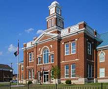 Bullitt County Courthouse in Shepherdsville | |
 Location in the U.S. state of Kentucky | |
 Kentucky's location in the U.S. | |
| Founded | 1796 |
| Named for | Alexander Scott Bullitt |
| Seat | Shepherdsville |
| Largest city | Shepherdsville |
| Area | |
| • Total | 300 sq mi (777 km2) |
| • Land | 297 sq mi (769 km2) |
| • Water | 3.2 sq mi (8 km2), 1.1% |
| Population (est.) | |
| • (2015) | 78,702 |
| • Density | 250/sq mi (97/km²) |
| Congressional district | 2nd |
| Time zone | Eastern: UTC-5/-4 |
| Website |
bullittcounty |
Bullitt County is a county in the U.S. state of Kentucky located in the far western Bluegrass region known as the Knobs. As of the 2010 census, the population was 74,319.[1] The county seat is Shepherdsville.[2] The county was founded in 1796.[3]
Located just south of the city of Louisville, Bullitt County is included in the Louisville/Jefferson County, KY-IN Metropolitan Statistical Area, commonly known as Kentuckiana.
The western fifth of the county (40,000 acres (160 km2)) is part of the United States Army post of Fort Knox and is reserved for military training.[4]
History
The first inhabitants of the land that would become Bullitt County were the Paleo-Indians who entered North America approximately 11,500 to 10,000 years BP. These people, whose ancestors can be traced back to Eastern and Central Asia, were nomadic. They were hunters and gatherers whose remains have been discovered near the area's mineral springs or salt licks, where big game such as the mammoth, bison and ground sloth once gathered. Native Americans were their descendants, including the Shawnee people, who probably considered this region part of their homeland and certainly valued it as a hunting ground. [5] [6]
Both France and Britain had traders and colonists who encountered the Shawnee. European colonization of the Americas led to competing claims between those nations to the lands west of the Appalachians and east of the Mississippi River. After suffering defeat by Great Britain in the Seven Years' War (known as the French and Indian War in its North American front), France ceded control in 1763 of its claimed territories.
For thousands of years before the county's formation, nutrient-rich salt licks attracted large herds of bison and other game to the area. Native American tribes made it their hunting grounds, as did the 18th century longhunter. In 1773, after the French and Indian War, the Virginia governor sent Captain Thomas Bullitt (uncle to Alexander Scott Bullitt) into the area to survey for land grants. The most historic of the county's salt licks, Bullitt's Lick, is named after him. As the Revolutionary War led to widespread salt shortages, the Lick became the site of Kentucky's first industry, attracting many settlers to the area.[7][8]
Colonial veterans of the war were promised land in what was later called Kentucky. Bullitt's Lick became an important saltwork to the region; its salt was harvested and sent by pack train and flatboat as far off as Illinois to the west. The Bullitt's Lick saltwork was Kentucky's first industry and in production until around 1830. By that time, the steamboat and importing of salt brought access to less expensive sources.
The first settlement of the area was also the first station on the Wilderness Road between Harrodsburg and the Falls of the Ohio. It was a fort called Brashear's Station or the Salt River Garrison, built in 1779 at the mouth of Floyd's Fork. Most of the county was settled after the American Revolutionary War. Shepherdsville, named after Adam Shepherd, a prosperous business man who purchased the land near the Falls of Salt River in 1793, is the oldest town and became the county seat.
In December 1796[3] the county of Bullitt, named after Thomas Bullitt's nephew and Kentucky's first Lieutenant Governor Alexander Scott Bullitt,[9] was organized from land taken from Jefferson and Nelson counties through an act approved on December 13, 1796 by the Kentucky General Assembly. In 1811, the northwestern area of the county expanded to include land given by Jefferson County. In 1824, an eastern area of the county was given to help form Spencer County.[10]
| “ | BE it enacted by the General Assembly, That from and after the first day of January next, all that part of the counties of Jefferson and Nelson included in the following bounds.. shall be one distinct county and called and known by the name of Bullitt. | ” | |
| — Kentucky General Assembly, December 13, 1796 | |||
Geography
According to the U.S. Census Bureau, the county has a total area of 300 square miles (780 km2), of which 297 square miles (770 km2) is land and 3.2 square miles (8.3 km2) (1.1%) is water.[11]
Adjacent counties
- Jefferson County – (north)
- Spencer County – (east)
- Nelson County – (southeast)
- Hardin County – (southwest)
Demographics
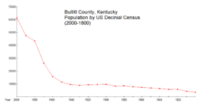
| Historical population | |||
|---|---|---|---|
| Census | Pop. | %± | |
| 1800 | 3,542 | — | |
| 1810 | 4,311 | 21.7% | |
| 1820 | 5,831 | 35.3% | |
| 1830 | 5,652 | −3.1% | |
| 1840 | 6,334 | 12.1% | |
| 1850 | 6,774 | 6.9% | |
| 1860 | 7,289 | 7.6% | |
| 1870 | 7,781 | 6.7% | |
| 1880 | 8,521 | 9.5% | |
| 1890 | 8,291 | −2.7% | |
| 1900 | 9,602 | 15.8% | |
| 1910 | 9,487 | −1.2% | |
| 1920 | 9,328 | −1.7% | |
| 1930 | 8,868 | −4.9% | |
| 1940 | 9,511 | 7.3% | |
| 1950 | 11,349 | 19.3% | |
| 1960 | 15,726 | 38.6% | |
| 1970 | 26,090 | 65.9% | |
| 1980 | 43,346 | 66.1% | |
| 1990 | 47,567 | 9.7% | |
| 2000 | 61,236 | 28.7% | |
| 2010 | 74,319 | 21.4% | |
| Est. 2015 | 78,702 | [12] | 5.9% |
| U.S. Decennial Census[13] 1790-1960[14] 1900-1990[15] 1990-2000[16] 2010-2013[1] | |||
As of the census[17] of 2000, there were 61,236 people, 22,171 households, and 17,736 families residing in the county. The population density was 205 per square mile (79/km2). There were 23,160 housing units at an average density of 77 per square mile (30/km2). The racial makeup of the county was 98.07% White, 0.38% Black or African American, 0.34% Native American, 0.27% Asian, 0.01% Pacific Islander, 0.16% from other races, and 0.77% from two or more races. 0.63% of the population were Hispanics or Latinos of any race.
There were 22,171 households out of which 39.00% had children under the age of 18 living with them, 65.40% were married couples living together, 10.40% had a female householder with no husband present, and 20.00% were non-families. 16.40% of all households were made up of individuals and 5.40% had someone living alone who was 65 years of age or older. The average household size was 2.75 and the average family size was 3.07.
In the county the population was spread out with 27.20% under the age of 18, 8.60% from 18 to 24, 32.70% from 25 to 44, 23.70% from 45 to 64, and 7.80% who were 65 years of age or older. The median age was 34 years. For every 100 females there were 98.90 males. For every 100 females age 18 and over, there were 97.20 males.
The median income for a household in the county was $50,058 (2005), and the median income for a family was $49,481. Males had a median income of $35,851 versus $24,098 for females. The per capita income for the county was $18,339. About 6.20% of families and 7.90% of the population were below the poverty line, including 11.40% of those under age 18 and 7.60% of those age 65 or over.
Law and government
Public safety
There are several police agencies in Bullitt County. The primary law enforcement agency in the county is the Bullitt County Sheriff.[18] The current sheriff of Bullitt County is Dave Greenwell. The Sheriff's Office is an elected position and is staffed by 34 deputy sheriffs, and four office staff. There are also 9 deputies and court certified security officers who provide courthouse security. The Sheriff's Office provides patrol, crime prevention, criminal investigation; and all other police related functions in the county. The primary areas for the sheriff's patrol division are the unincorporated areas in Bullitt County they also provide backup for the various city police agencies. Since 1989 the Sheriff's Office has been contracted by the County Fiscal Court to provide the county police force to the citizens of Bullitt County after the County Police Department was folded. The County Sheriff's Office has deputies assigned to the drug task force, arson task force, accident reconstruction team, rapid response team, technical operations, ATV squad, boat patrol, hostage negotiations, and an incident command team. Most of the services are provided while on duty or for free by special deputies who serve their county for free, even paying for their own equipment, uniforms, and sidearm.
Fire protection is provided by both Kentucky Chapter 75 and 95 Districts and Departments. Zoneton Fire Protection District, Mount Washington Fire Protection District, and the Shepherdsville Division of Fire are currently staffed with a 24-hour professional firefighting staff. Nichols, Southeast Bullitt, and Lebanon Junction are all volunteer-based.
- Zoneton Fire District
- Mt. Washington Fire District
- Nichols Fire District
- Southeast Bullitt Fire Department
- Shepherdsville Fire Department
- Lebanon Junction Fire Department
The Bullitt County Emergency Medical Service (BCEMS) provides all emergency medical care and transport in Bullitt County. BCEMS is a division of Bullitt County Fiscal Court and authorized and funded by the county through taxes.
Economy

Bullitt County, which is bisected by I-65, the main north-south transportation corridor, has grown into a thriving distribution hub, and several of its major business parks are approximately 16 miles (26 km) from Louisville International Airport and UPS' global air-freight hub Worldport. More than 6,000,000 square feet (560,000 m2) of distribution, warehousing and other complexes have been built and absorbed in Bullitt County since 2000, and additional construction is ongoing.
In October 2011, Zappos, which already is Bullitt County's largest employer, with more than 2,300 full-time workers, was reported to have plans to add 5,000 more employees in the next three years. The company has also outgrown the more than 1 million square feet of processing space it operates in Bullitt County and plans to build a 1.2 million-square-foot facility next year to keep pace with its rapid growth. [19]
Bullitt County residents have easy access to major job centers such as Elizabethtown, Fort Knox, and Louisville.
Education
Bullitt County is served by Bullitt County Public Schools.
There are six middle schools:
- Bernheim Middle School
- Bullitt Lick Middle School
- Eastside Middle School
- Hebron Middle School
- Mount Washington Middle School
- Zoneton Middle School
There are four high schools:
- Bullitt Central High School, located in Shepherdsville
- Bullitt East High School, located in Mount Washington
- North Bullitt High School, located in Hebron Estates (served by the Shepherdsville post office)
- Riverview High School
Communities
Although large-scale residential development has not made its way south of Shepherdsville, the growth is apparent in and around that town and in Mount Washington, as well as points north along I-65 towards Hillview. Both Shepherdsville and Mount Washington have stretched their boundaries such that they are nearly touching each other. The 10-mile (16 km) stretch of Kentucky 44 that connects the two towns has homes through nearly the entire expanse.
See also
References
- 1 2 "State & County QuickFacts". United States Census Bureau. Retrieved March 5, 2014.
- ↑ "Find a County". National Association of Counties. Archived from the original on 2011-05-31. Retrieved 2011-06-07.
- 1 2 "BULLITT COUNTY".
- ↑ Kempf, Gary. The Land Before Fort Knox, Arcadia Publishing, 2004, p. 11
- ↑ Tankersley, Kenneth B. (1996). "Ice Age Hunters And Gatherers". In Lewsi, R. Barry. Kentucky Archeology. The University Press of Kentucky. ISBN 0-8131-1907-3.
- ↑ Clark, Jerry E. (1993). The Shawnee. The University Press of Kentucky. ISBN 0-8131-1839-5.
- ↑ Pack, Tom. History of Bullitt County. Bullitt County Historical Commission, 1974, pp. 3-6.
- ↑ Clark, Thomas D. (1954). "England Moves West". A History of Kentucky. The John Bradford Press.
- ↑ The Register of the Kentucky State Historical Society, Volume 1. Kentucky State Historical Society. 1903. p. 34.
- ↑ Hartley, Charles (December 29, 2010). "The Creation of Bullitt County". The Bullitt County History Museum.
- ↑ "2010 Census Gazetteer Files". United States Census Bureau. August 22, 2012. Retrieved August 12, 2014.
- ↑ "County Totals Dataset: Population, Population Change and Estimated Components of Population Change: April 1, 2010 to July 1, 2015". Retrieved July 2, 2016.
- ↑ "U.S. Decennial Census". United States Census Bureau. Archived from the original on April 22, 2013. Retrieved August 12, 2014.
- ↑ "Historical Census Browser". University of Virginia Library. Retrieved August 12, 2014.
- ↑ "Population of Counties by Decennial Census: 1900 to 1990". United States Census Bureau. Retrieved August 12, 2014.
- ↑ "Census 2000 PHC-T-4. Ranking Tables for Counties: 1990 and 2000" (PDF). United States Census Bureau. Retrieved August 12, 2014.
- ↑ "American FactFinder". United States Census Bureau. Archived from the original on 2013-09-11. Retrieved 2008-01-31.
- ↑ "Bullitt County Sheriff's Office".
- ↑ Karman III, John R. (October 28, 2011). "Zappos plans a lot of growth -- Business First October 28, 2011.".
External links
- Bernheim Arboretum and Research Forest
- Bullitt County government and commerce website
- Bullitt County History Museum
- Bullitt County Attractions
Municipalities and communities of Bullitt County, Kentucky, United States | ||
|---|---|---|
| Cities | | |
| CDP | ||
| Unincorporated communities | ||

Coordinates: 37°58′N 85°42′W / 37.97°N 85.70°W