Sirumugai
| Sirumugai சிறுமுகை Sirumugaipudur | |
|---|---|
| suburb | |
 Sirumugai Location in Tamil Nadu, India | |
| Coordinates: 11°19′20.1″N 77°00′31.9″E / 11.322250°N 77.008861°ECoordinates: 11°19′20.1″N 77°00′31.9″E / 11.322250°N 77.008861°E | |
| Country |
|
| State | Tamil Nadu |
| District | Coimbatore |
| Area | |
| • Total | 14.2 km2 (5.5 sq mi) |
| Elevation | 292 m (958 ft) |
| Population (2011) | |
| • Total | 18,223 [1] |
| Languages | |
| • Official | Tamil, Kannada |
| Time zone | IST (UTC+5:30) |
| Vehicle registration | TN-40 |
Sirumugai, சிறுமுகை, is a Panchayat town and a suburb in Coimbatore rural district in the Indian state of Tamil Nadu.
Geography

nature's beauty
Sirumugai is located at 11°20′N 77°01′E / 11.33°N 77.02°E.[2] It has an average elevation of 292 metres (958 feet). It is situated in the northern part of Coimbatore district, on the banks of the Bhavani River.
Demographics
As of 2011 Census of India,[3] The Sirumugai Town Panchayat has population of 18,223 of which 9,015 are males while 9,208 are females as per report released by Census India 2011.
Gallery
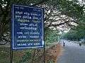 Welcome board of Sirumugai
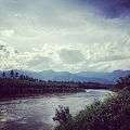 Bhavani River
 Panoramic view of Sirumugai
References
| Wikimedia Commons has media related to Sirumugai. |
- ↑ http://www.citypopulation.de/php/india-tamilnadu.php?cityid=3341201000
- ↑ Falling Rain Genomics, Inc - Sirumugai
- ↑ "2011 Census of India - Sirumugai". Government of India (2011). Census of India.
| District Headquarters | 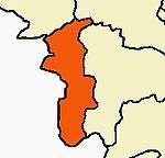 --> --> | |
|---|---|---|
| Country | ||
| State | ||
| Region | ||
| Taluks | ||
| Municipal Corporations | ||
| Municipalities | ||
| Rivers | ||
| History | ||
| Places of interest |
| |
| Universities | ||
| ||
| State symbols |
|
|---|---|
| Governance |
|
| Topics | |
| Districts |
|
| Major cities | |
This article is issued from Wikipedia - version of the 2/20/2016. The text is available under the Creative Commons Attribution/Share Alike but additional terms may apply for the media files.