Maysville, Kentucky micropolitan area
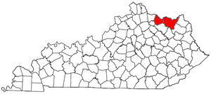
The Maysville Micropolitan Statistical Area (μSA), as defined by the United States Census Bureau, is coterminous with Mason County, Kentucky, whose county seat and largest city is Maysville. As of the 2010 census, the population of Mason County and the current µSA was 17,490, and 2014 Census Bureau estimates place the population at 17,166.[1]
Prior to a 2013 change in Census Bureau definitions, the Maysville µSA also included Lewis County, Kentucky. At that time, the µSA was redefined to consist solely of Mason County, and was also added as part of the Cincinnati-Wilmington-Maysville Combined Statistical Area.
As of the 2000 census, the μSA, which then consisted of Mason and Lewis Counties, had a population of 30,892 (though a July 1, 2009 estimate placed the population at 31,130).[2]
County
Communities
Incorporated places
- Dover
- Germantown (partial)
- Maysville (principal city)
- Sardis (partial)
Unincorporated places
Demographics
As of the census[3] of 2000, there were 30,892 people, 12,269 households, and 8,747 families residing within the μSA. The racial makeup of the μSA was 94.55% White, 3.99% African American, 0.18% Native American, 0.21% Asian, 0.01% Pacific Islander, 0.35% from other races, and 0.71% from two or more races. Hispanic or Latino of any race were 0.72% of the population.
The median income for a household in the μSA was $26,202, and the median income for a family was $31,683. Males had a median income of $26,145 versus $19,990 for females. The per capita income for the μSA was $14,310.
See also
References
- ↑ "Table 1. Annual Estimates of the Population of Metropolitan and Micropolitan Statistical Areas: April 1, 2010 to July 1, 2014" (CSV). 2014 Population Estimates. United States Census Bureau, Population Division. March 2015. Retrieved March 26, 2015.
- ↑ "Table 1. Annual Estimates of the Population of Metropolitan and Micropolitan Statistical Areas: April 1, 2000 to July 1, 2009 (CBSA-EST2009-01)" (CSV). 2009 Population Estimates. United States Census Bureau, Population Division. 2010-03-23. Retrieved 2010-03-25.
- ↑ "American FactFinder". United States Census Bureau. Archived from the original on September 11, 2013. Retrieved 2008-01-31.
