Kure, Hiroshima
| Kure 呉市 | ||
|---|---|---|
| Core city | ||
|
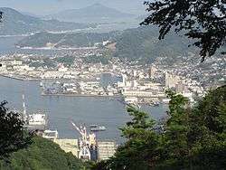
Port of Kure seen from Mount Yasumi | ||
| ||
|
Location of Kure in Hiroshima Prefecture | ||
 Kure Location in Japan | ||
| Coordinates: 34°15′N 132°34′E / 34.250°N 132.567°ECoordinates: 34°15′N 132°34′E / 34.250°N 132.567°E | ||
| Country | Japan | |
| Region | Chūgoku (Sanyō) | |
| Prefecture | Hiroshima Prefecture | |
| Government | ||
| • Mayor | Kazutoshi Komura | |
| Area | ||
| • Total | 352.80 km2 (136.22 sq mi) | |
| Population (May 1, 2015) | ||
| • Total | 228,030 | |
| • Density | 646/km2 (1,670/sq mi) | |
| Symbols | ||
| • Tree | Oak | |
| • Flower | Camellia | |
| Time zone | Japan Standard Time (UTC+9) | |
| City hall address |
4-1-6 Chūō, Kure-shi, Hiroshima-ken 737-8501 | |
| Website |
www | |
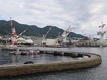
Kure (呉市 Kure-shi) is a port and major shipbuilding city situated on the Seto Inland Sea in Hiroshima Prefecture, Japan. With a strong industrial heritage Kure hosts the second oldest naval dockyard in Japan and remains an important base for the Japan Maritime Self-Defence Force (JMSDF).
As of May 1, 2015, the city has an estimated population of 228,030 and a population density of 646 persons per km². The total area is 352.80 km².
History

The Kure Naval District was first established in 1889, leading to the construction of the Kure Naval Arsenal and the rapid growth of both steel production and shipbuilding in the city. The city itself was formally incorporated on October 1, 1902. From 1889 until the end of World War II, the city served as the headquarters of the Kure Naval District.
Kure dockyards recorded a number of significant engineering firsts including; in 1905 the launching of the first major domestically built capital ship, the cruiser Tsukuba,[1] and, in 1940, the launching of the largest battleship ever built, the Yamato.[2]
During the Pacific War, Kure acted as Japan's single largest naval base and arsenal. Most of the city's industry and workforce were employed in the service of the naval installations, munitions factories and associated support functions. In the later stages of the conflict Kure came under sustained aerial bombardment culminating in the Bombing of Kure in June and July 1945.
From February 1946 until the end of Japan's postwar occupation in 1952, military establishments in Kure served at the operational headquarters for the British Commonwealth Occupation Force.
Historic Timeline
- July 1, 1889 — Kure Naval District established.
- 1895 — Kure naval shipyard established, initially as a subsidiary of the Onohama Shipyards in Kobe.
- October 1, 1902 — The towns of Washō and Futagawa and the villages of Miyahara and Sōyamada merge to form the city of Kure.
- November 10, 1903 — Kure Naval Arsenal established.
- December 27, 1903 Kure rail line opens providing direct rail access to Hiroshima
- April 1, 1928 — The towns of Kegoya, Yoshiura, and Aga merge into Kure.
- April 21, 1941 — The town of Nigata and the village of Hiro incorporated into Kure.
- May 5, 1945 — Bombing of Hiro Naval Arsenal.
- June 22, 1945 — Bombing of Kure Naval Arsenal.
- July 1, 1945 — Kure Air Raid.
- July 24–28, 1945 — Battle of Kure, American bombers attack the remaining fleet in Kure Naval Base.
- July 1, 1954 — Japan Maritime Self Defense Forces founded.
- October 1, 1956 — The town of Tennō and the village of Shōwa in Aki District, and the village of Gōhara in Kamo District merge into Kure.
- November 1, 2000 — Kure becomes a Special City
- April 1, 2003 — The town of Shimokamagari (from Aki District) was merged into Kure.
- April 1, 2004 —The town of Kawajiri (from Toyota District) was merged into Kure.
- March 20, 2005 — The towns of Ondo, Kurahashi and Kamagari (all from Aki District), and the towns of Yasuura, Toyohama and Yutaka (all from Toyota District) were merged into Kure.
The city continues as a major maritime center hosting both the dockyards of Japan Marine United and numerous shore based facilities of the JMSDF including training centers and a major hospital. The city serves as the home port of an Escort Flotilla (Destroyers), a Submarine Flotilla and the Training Squadron of the JMSDF Regional Kure District.
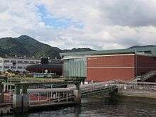
Since 2005 Kure has also attracted attention as a tourism center with the Yamato Museum hosting a 1:10 scale model of the battleship Yamato alongside a waterfront JMSDF museum of naval history.
Geography
Kure is located 20 kilometres (10 mi) south-east of Hiroshima city and faces the Seto Inland Sea. Surrounded by steep hillsides to the north, the two major commercial and industrial centers of the city are bisected by Mount Yasumi 497 m (1,631 ft). The city is next to the Setonaikai National Park. As well as densely populated urban and industrial centers, the city also incorporates sparsely inhabited outlying islands such as Kurahashi, Shimo-kamagari and Kami-kamagari.
Climate
Kure has a humid subtropical climate (Köppen climate classification Cfa) with hot summers and cool winters. Precipitation is significant throughout the year and is heaviest in summer.
| Climate data for Kure, Hiroshima | |||||||||||||
|---|---|---|---|---|---|---|---|---|---|---|---|---|---|
| Month | Jan | Feb | Mar | Apr | May | Jun | Jul | Aug | Sep | Oct | Nov | Dec | Year |
| Average high °C (°F) | 8.8 (47.8) |
9.2 (48.6) |
12.5 (54.5) |
18.2 (64.8) |
22.4 (72.3) |
25.5 (77.9) |
29.7 (85.5) |
31.2 (88.2) |
27.3 (81.1) |
22.1 (71.8) |
16.8 (62.2) |
11.7 (53.1) |
19.62 (67.32) |
| Daily mean °C (°F) | 5.3 (41.5) |
5.5 (41.9) |
8.4 (47.1) |
13.8 (56.8) |
18.1 (64.6) |
21.8 (71.2) |
26.1 (79) |
27.4 (81.3) |
23.7 (74.7) |
18.1 (64.6) |
12.7 (54.9) |
7.8 (46) |
15.73 (60.3) |
| Average low °C (°F) | 1.8 (35.2) |
1.9 (35.4) |
4.3 (39.7) |
9.8 (49.6) |
14.2 (57.6) |
18.6 (65.5) |
23.2 (73.8) |
24.3 (75.7) |
20.5 (68.9) |
14.3 (57.7) |
8.8 (47.8) |
3.9 (39) |
12.13 (53.83) |
| Average precipitation mm (inches) | 45.1 (1.776) |
59.8 (2.354) |
98.5 (3.878) |
149.6 (5.89) |
138.9 (5.469) |
258.4 (10.173) |
206.1 (8.114) |
113.5 (4.469) |
182.0 (7.165) |
100.1 (3.941) |
68.9 (2.713) |
35.3 (1.39) |
1,456.2 (57.332) |
| Average snowfall cm (inches) | 1 (0.4) |
1 (0.4) |
0 (0) |
0 (0) |
0 (0) |
0 (0) |
0 (0) |
0 (0) |
0 (0) |
0 (0) |
0 (0) |
0 (0) |
2 (0.8) |
| Average relative humidity (%) | 63 | 64 | 64 | 67 | 70 | 76 | 77 | 74 | 72 | 67 | 67 | 65 | 68.8 |
| Mean monthly sunshine hours | 140.9 | 135.2 | 173.7 | 178.3 | 199.5 | 155.9 | 183.7 | 213.2 | 157.7 | 172.6 | 148.8 | 138.8 | 1,998.3 |
| Source: NOAA (1961-1990)[3] | |||||||||||||
Transportation
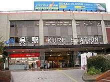
Kure is served by the Kure Line, operated by West Japan Railway Company (JR West). It leads to Hiroshima, which is a terminal station.
There has been a municipal bus since December 1, 1942. The Kure City Transportation Bureau (Kure City Bus) started using natural gas in 2002. There is a bus route run by Hiroshima Electric Railway, too. In addition, there is Bōyo Kisen, which operates the San'yō Bus and Setouchi Sankō which runs two bus enterprises.
National Route 31 spreads out from Kure to Kaita, but the distance of the road is short. National Route 185 is connected from Kure to Mihara. This road has a view of the Inland Sea. National Route 375 is a 165 km long road to be connected from Kure to Ōda, Shimane. U.S. forces can use this way for their ammunition transportation. National Route 487 spreads out from Kure to the city of Hiroshima. This road crosses the Ondo Bridge, and goes around Etajima.
Though they are independent roads, separate from National Routes, there are a series of access roads toward the archipelago of the city. The Akinada Islands series of bridges conclude at Shimokamagari island, Kamikamagari island, Toyoshima, Osakishimojima, Herashima, Nakanoshima at seven bridges. Toyoshima Bridge, concluding at Toyoshima regards traffic of a ship as Kamikamagari island, and is 50 m high from the surface of the sea.
Economy
- Japan Marine United, formerly IHI Marine United
- Nisshin Steel
- Yodogawa Steel Works
- Mitsubishi Hitachi Power Systems
- Sailor Pen Company
- Disco Corporation
- Mitutoyo
- Oji Paper Company
Tourism
Museums
- Kure Municipal Museum of Art and Museum Avenue
- Irifuneyama Memorial Museum
- Sannose Gohonjin Art and Culture
- Rantokaku Art Museum
- Kurahashi-cho Nagato Museum of Shipbuilding History
- JMSDF Kure Museum (Displaying Yūshio-class submarine Akishio), nicknamed Iron Whale Museum
- Yamato Museum
Shrines
- Kameyama Shrine
Historical places
- Former Kure-chinjufu
- Mitarai
- Former House of Prince Takamatsu
- House of Kimiyo Fjii
Parks and gardens
- Rekishi-no-mieru-Oka and Park
- Nagasako Park
- Allay Karasu Kojima Park
- Ondono-seto and Park
- Setonaikai National Park
- Kure Port-pia Park
- Nikokyo Park
Mountains
- Mount Noro
- Haiga-mine
- Mount Yasumi
- Nikyu-kyo
- Honjo Suigenchi
Beaches
- Romantic Beach Karuga
- Kajigahama Beach
Festivals
- Kure Port Festival
- Kure Fireworks above the Sea (late July or early August)
- Kameyama Shrine Festival (2nd Sunday in October, and the day before)
Sister cities
 Daisen, Tottori, Japan
 Bremerton, Washington, USA
 Marbella, Spain
 Jinhae-gu, South Korea
 Wenzhou, China - sister port city
 Galyani Vadhana District, Thailand
Notable people
Musicians
Authors
Sports
See also
References
- ↑ Evans, David (1997). Kaigun:Strategy, Tactics and Technology in the Imperial Japanese Navy, 1887-1941. Annapolis, MD: First Naval Institute Press. p. 159. ISBN 978-0-87021-192-8.
- ↑ Johnson, William (2006). The Pacific Campaign in World War II: From Pearl Harbor to Guadalcanal. Abingdon, Oxon: Routledge. p. 17. ISBN 978-0-415-70175-4.
- ↑ "Kure Climate Normals 1961-1990". National Oceanic and Atmospheric Administration. Retrieved January 6, 2013.
External links
| Wikimedia Commons has media related to Kure, Hiroshima. |
| Wards of Hiroshima | |
|---|---|
| Core cities | |
| Cities | |
| Aki District | |
| Jinseki District | |
| Sera District | |
| Toyota District | |
| Yamagata District | |