Kōfu
| Kōfu 甲府市 | |||
|---|---|---|---|
| Special city | |||
|
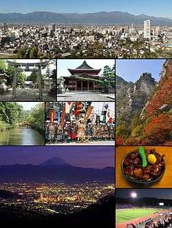
View from Sakaorimiya Kai-Zenko-ji, Kakueno in autumn Moats of Kofu Castle, Takeda Shingen festival Night view of Kofu, Kofu motsu-ni stew Kose Sports Stadium | |||
| |||
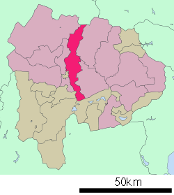 Location of Kōfu in Yamanashi Prefecture | |||
 Kōfu Location of Kōfu in Yamanashi Prefecture | |||
| Coordinates: 35°39′43.7″N 138°34′5.6″E / 35.662139°N 138.568222°ECoordinates: 35°39′43.7″N 138°34′5.6″E / 35.662139°N 138.568222°E | |||
| Country | Japan | ||
| Region | Chūbu (Tōkai) | ||
| Prefecture | Yamanashi Prefecture | ||
| Government | |||
| • -Mayor | Yūichi Higuchi (since February 2015) | ||
| Area | |||
| • Total | 212.47 km2 (82.04 sq mi) | ||
| Population (November 2015) | |||
| • Total | 193,127 | ||
| • Density | 909/km2 (2,350/sq mi) | ||
| Time zone | Japan Standard Time (UTC+9) | ||
| - Tree | Quercus | ||
| - Bird | Common kingfisher | ||
| Phone number | 055-237-1161 | ||
| Website |
www | ||


Kōfu (甲府市 Kōfu-shi) is the capital city of Yamanashi Prefecture in Japan.
As of November 1, 2015, the city had an estimated population of 193,127 and a population density of 909 persons per km2. The total area was 212.41 square kilometres (82.01 sq mi). Kōfu's name means "capital of Kai Province". During the Sengoku period, it was famous as the stronghold of Takeda Shingen.
Geography
Kōfu is located in north-central Yamanashi Prefecture, extending from the northern border of the prefecture with Nagano Prefecture, south until it almost reaches the southern border of the prefecture. It is narrow along its east-west axis. The city bisects the Kofu Basin, and is at an elevation of between 250 and 300 meters, surrounded by mountains on all sides. Much of the northern portion of the city is within the borders of the Chichibu-Tama-Kai National Park
Surrounding municipalities
History
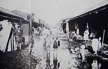

Archaeologists have discovered evidence of human settlement in the Kōfu area dating to the Japanese Paleolithic period, with continuous settlement through the Jomon, Yayoi and Kofun periods. During the Nara period, the provincial temple of Kai Province was established in what is now Kōfu, indicating that the Nara period provincial capital was located nearby, as the name of the city implies. During the Heian period, a branch of the Minamoto clan, the “Kai-Genji” ruled over vast shōen estates, and developed a military force noted for its use of cavalry. By the Muromachi period, a branch of the Kai-Genji, the Takeda clan came to dominate the area, and built a castle in what is now part of Kōfu. Under the rule of Takeda Nobutora, Kōfu was rebuilt as a castle town starting in 1519, and remained the capital of the Takeda clan under Takeda Shingen and his son Takeda Katsuyori. During the Edo period, Kai Province was tenryō territory ruled directly to by the Tokugawa shogunate, and Kōfu Castle remained its administrative center. Following the Meiji restoration, with the establishment of the municipalities system, the town of Kōfu was proclaimed on July 1, 1889. During World War II, much of the city was destroyed by United States Army Air Forces B-29 Superfortress bombers during a major air raid during the night of 6 July 1945.[1]
Kōfu is designated as one of the special cities of Japan. On March 1, 2006, Kōfu, with a population of 193,795, absorbed the town of Nakamichi (from Higashiyatsushiro District), and the northern part of the village of Kamikuishiki (from Nishiyatsushiro District) increasing the population to 201,184.
Climate
Kōfu has the typical Honshū humid subtropical climate, though it is less wet than either the south or Sea of Japan coast due to its location in a shielded mountain valley. Temperature ranges are noticeably greater than in coastal regions: in 2004 Kōfu reached a temperature of 40 °C (104 °F) previously almost unknown in Japan, and it has fallen below 0 °C (32 °F) as early as 26 October,[2] which is about a month before the earliest freezing temperatures in such coastal cities as Kanazawa or Tokyo.
| Climate data for Kōfu, Yamanashi (1981~2010) | |||||||||||||
|---|---|---|---|---|---|---|---|---|---|---|---|---|---|
| Month | Jan | Feb | Mar | Apr | May | Jun | Jul | Aug | Sep | Oct | Nov | Dec | Year |
| Record high °C (°F) | 20.2 (68.4) |
25.4 (77.7) |
28.8 (83.8) |
33.1 (91.6) |
34.3 (93.7) |
38.1 (100.6) |
40.4 (104.7) |
39.8 (103.6) |
38.0 (100.4) |
33.8 (92.8) |
29.6 (85.3) |
24.9 (76.8) |
40.4 (104.7) |
| Average high °C (°F) | 8.8 (47.8) |
10.3 (50.5) |
14.2 (57.6) |
20.4 (68.7) |
24.6 (76.3) |
27.3 (81.1) |
30.9 (87.6) |
32.5 (90.5) |
28.0 (82.4) |
21.9 (71.4) |
16.4 (61.5) |
11.2 (52.2) |
20.5 (68.9) |
| Daily mean °C (°F) | 2.8 (37) |
4.3 (39.7) |
8.0 (46.4) |
13.8 (56.8) |
18.3 (64.9) |
21.9 (71.4) |
25.5 (77.9) |
26.6 (79.9) |
22.8 (73) |
16.5 (61.7) |
10.4 (50.7) |
5.0 (41) |
14.7 (58.5) |
| Average low °C (°F) | −2.4 (27.7) |
−1 (30) |
2.7 (36.9) |
8.3 (46.9) |
13.3 (55.9) |
17.9 (64.2) |
21.8 (71.2) |
22.8 (73) |
19.1 (66.4) |
12.3 (54.1) |
5.5 (41.9) |
−0.2 (31.6) |
10.0 (50) |
| Record low °C (°F) | −19.5 (−3.1) |
−17.2 (1) |
−11.4 (11.5) |
−4.6 (23.7) |
−0.6 (30.9) |
5.4 (41.7) |
12.6 (54.7) |
13.2 (55.8) |
6.0 (42.8) |
−1.8 (28.8) |
−6 (21) |
−11.7 (10.9) |
−19.5 (−3.1) |
| Average precipitation mm (inches) | 40.2 (1.583) |
46.1 (1.815) |
87.9 (3.461) |
77.7 (3.059) |
86.3 (3.398) |
122.5 (4.823) |
132.6 (5.22) |
149.5 (5.886) |
180.3 (7.098) |
125.2 (4.929) |
54.9 (2.161) |
32.1 (1.264) |
1,135.3 (44.697) |
| Average snowfall cm (inches) | 13 (5.1) |
10 (3.9) |
4 (1.6) |
0 (0) |
0 (0) |
0 (0) |
0 (0) |
0 (0) |
0 (0) |
0 (0) |
0 (0) |
1 (0.4) |
28 (11) |
| Average precipitation days (≥ 0.5 mm) | 4.9 | 5.7 | 9.8 | 8.9 | 9.7 | 12.1 | 12.5 | 10.1 | 11.2 | 9.4 | 6.3 | 4.2 | 104.8 |
| Average snowy days | 4.5 | 3.1 | 0.9 | 0.1 | 0.0 | 0.0 | 0.0 | 0.0 | 0.0 | 0.0 | 0.0 | 0.6 | 9.2 |
| Average relative humidity (%) | 57 | 54 | 56 | 58 | 64 | 71 | 73 | 71 | 72 | 71 | 68 | 61 | 64.7 |
| Mean monthly sunshine hours | 204.8 | 189.9 | 198.7 | 202.0 | 196.3 | 148.9 | 164.1 | 197.3 | 142.2 | 160.9 | 176.6 | 201.3 | 2,183 |
| Source #1: Japan Meteorological Agency[3] | |||||||||||||
| Source #2: Japan Meteorological Agency (records)[4] | |||||||||||||
Education
Colleges and universities
- University of Yamanashi
- Yamanashi Prefectural University
- Yamanashi Gakuin University
- Yamanashi Eiwa College
- Yamanashi Gakuin Junior College
Primary and secondary education
- Kōfu has 25 public and two private elementary schools, eleven public, three private middle schools and one combined national elementary/middle school, and eight public and five private high schools.
Transportation
Railway
- East Japan Railway Company – Chūō Main Line
- Central Japan Railway Company - Minobu Line
- Kokubo - Kai-Sumiyoshi - Minami-Kōfu - Zenkōji - Kanente - Kōfu
Highway
- Chūō Expressway
- National Route 20
- National Route 52
- National Route 140
- National Route 137
- National Route 358
- National Route 411
Media
Local attractions
- Kai-Zenkō-ji temple
- Maizuru Castle Park
- Takeda Shrine
- Yōgaiyama Castle
- Yumura Spa
- Yamanashi Science Museum
- Shōsen Kyō (Valley)
Notable people from Kofu
- Banjō Ginga – voice actor
- Hideo Hagiwara – woodblock print artist
- Tsuneo Horiuchi – former manager of Yomiuri Giants baseball team
- Takao Kajimoto – former professional baseball player and sports announcer
- Yoshinobu Kanemaru – professional wrestler
- Hidetoshi Nakata - football player who last played with the Bolton Wanderers in the Premier League, but has since retired following the 2006 World Cup.
- Naoko Takeuchi – manga artist, creator of Sailor Moon and other comics.
- Fujizakura Yoshimori – former sumo wrestler
Sport
- A J-League football team, Ventforet Kofu is based in Kōfu. They currently play in the J. League Division 1, and their home ground is the Kose Sports Stadium.
- Yamanashi Iida Baseball Stadium
Sister cities
-
 Des Moines, Iowa, USA, [5] since August 16, 1958
 -
 Pau, Pyrénées-Atlantiques, France, [6] since August 18, 1975
 - Lodi, California, USA, since April 11, 1981[7]
-
 Chengdu, China,[6] since September 27, 1984
 -
 Yamatokoriyama, Nara, Japan, since January 22, 1992
 -
 Cheongju, South Korea,[6] since September 26, 2002
References
- ↑ Ijiri, Toshiyuki (1991). Paul Rusch. Cincinnati, Ohio: Forward Movement Publications. p. 167.
- ↑ http://www.data.jma.go.jp/obd/stats/etrn/view/rank_s.php?prec_no=19&prec_ch=%8B%FA%98H%8Ex%92%A1&block_no=47638&block_ch=%8B%FA%98H&year=&month=10&day=&view= 観測史上1~10位の値(10月としての値)
- ↑ "平年値(年・月ごとの値)". Japan Meteorological Agency. Retrieved 2011-11-26.
- ↑ "観測史上1~10位の値(年間を通じての値)". Japan Meteorological Agency. Retrieved 2011-11-26.
- ↑ "US-Japan Sister Cities by State". Asia Matters for America. Honolulu, HI: East-West Center. Retrieved 20 November 2015.
- 1 2 3 "International Exchange". List of Affiliation Partners within Prefectures. Council of Local Authorities for International Relations (CLAIR). Retrieved 21 November 2015.
- ↑ "Consolidation of Local Governments in Japan and Effects on Sister City Relationships," Consulate General of Japan, San Francisco
External links
| Wikivoyage has a travel guide for Kofu. |
| Wikimedia Commons has media related to Kofu, Yamanashi. |
- Official website
- Yamanashi International Association
- teacher website-English
- Yamanashi teacher's website-English
| Special city | ||
|---|---|---|
| Cities | ||
| Kitatsuru District | ||
| Minamikoma District | ||
| Minamitsuru District | ||
| Nakakoma District | ||
| Nishiyatsushiro District | ||