Casey County, Kentucky
| Casey County, Kentucky | |
|---|---|
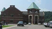 Casey County courthouse in Liberty | |
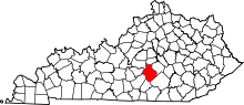 Location in the U.S. state of Kentucky | |
 Kentucky's location in the U.S. | |
| Founded | November 14, 1806 |
| Named for | Colonel William Casey |
| Seat | Liberty |
| Largest city | Liberty |
| Area | |
| • Total | 446 sq mi (1,155 km2) |
| • Land | 444 sq mi (1,150 km2) |
| • Water | 1.5 sq mi (4 km2), 0.3% |
| Population | |
| • (2010) | 15,955 |
| • Density | 36/sq mi (14/km²) |
| Congressional district | 1st |
| Time zone | Eastern: UTC-5/-4 |
| Website |
www |
Casey County is a county located in the U.S. Commonwealth of Kentucky. As of the 2010 census, the population was 15,955.[1] Its county seat is Liberty.[2] The county was formed in 1806 from the western part of Lincoln County[3] and named for Colonel William Casey, a pioneer settler who moved his family to Kentucky in 1779.[4] It is the only Kentucky county entirely in the Knobs region. Casey County is home to annual 'Casey County Apple Festival', and is a prohibition or dry county. It is considered part of the Appalachian region of Kentucky.
History
Casey County was established in 1806 from land given by Lincoln County. The third and present courthouse was built in 1889.[5]
In 2015, County Clerk Casey Davis received national press when he announced he would deny same-sex marriage licenses, as a show of solidarity with fellow county clerk Kim Davis, who was criticized and later jailed for doing the same thing in Rowan County, Kentucky.[6]
Geography
According to the U.S. Census Bureau, the county has a total area of 446 square miles (1,160 km2), of which 444 square miles (1,150 km2) is land and 1.5 square miles (3.9 km2) (0.3%) is water.[7]
The highest point in Casey County is Green River Knob at 1,789 feet (545 m).
Adjacent counties
- Boyle County (north)
- Lincoln County (northeast)
- Pulaski County (southeast)
- Russell County (south/CST Border)
- Adair County (southwest/CST Border)
- Taylor County (west)
- Marion County (northwest)
Major highways
Demographics
| Historical population | |||
|---|---|---|---|
| Census | Pop. | %± | |
| 1810 | 3,285 | — | |
| 1820 | 4,349 | 32.4% | |
| 1830 | 4,342 | −0.2% | |
| 1840 | 4,939 | 13.7% | |
| 1850 | 6,556 | 32.7% | |
| 1860 | 6,466 | −1.4% | |
| 1870 | 8,884 | 37.4% | |
| 1880 | 10,983 | 23.6% | |
| 1890 | 11,848 | 7.9% | |
| 1900 | 15,144 | 27.8% | |
| 1910 | 15,479 | 2.2% | |
| 1920 | 17,213 | 11.2% | |
| 1930 | 16,747 | −2.7% | |
| 1940 | 19,962 | 19.2% | |
| 1950 | 17,446 | −12.6% | |
| 1960 | 14,327 | −17.9% | |
| 1970 | 12,930 | −9.8% | |
| 1980 | 14,818 | 14.6% | |
| 1990 | 14,211 | −4.1% | |
| 2000 | 15,447 | 8.7% | |
| 2010 | 15,955 | 3.3% | |
| Est. 2015 | 15,808 | [8] | −0.9% |
| U.S. Decennial Census[9] 1790-1960[10] 1900-1990[11] 1990-2000[12] 2010-2013[1] | |||
As of the census[13] of 2000, there were 15,447 people, 6,260 households, and 4,419 families residing in the county. The population density was 35 per square mile (14/km2). There were 7,242 housing units at an average density of 16 per square mile (6.2/km2). The racial makeup of the county was 98.30% White, 0.33% Black or African American, 0.28% Native American, 0.06% Asian, 0.05% Pacific Islander, 0.31% from other races, and 0.66% from two or more races. 1.28% of the population were Hispanic or Latino of any race.
There were 6,260 households out of which 31.00% had children under the age of 18 living with them, 56.10% were married couples living together, 10.80% had a female householder with no husband present, and 29.40% were non-families. 26.80% of all households were made up of individuals and 12.60% had someone living alone who was 65 years of age or older. The average household size was 2.44 and the average family size was 2.94.
24.50% of the population was under the age of 18, 8.20% from 18 to 24, 27.50% from 25 to 44, 24.70% from 45 to 64, and 15.10% who were 65 years of age or older. The median age was 38 years. For every 100 females there were 95.60 males. For every 100 females age 18 and over, there were 92.60 males.
The median income for a household in the county was $21,580, and the median income for a family was $27,044. Males had a median income of $22,283 versus $17,885 for females. The per capita income for the county was $12,867. About 20.70% of families and 25.50% of the population were below the poverty line, including 32.10% of those under age 18 and 29.60% of those age 65 or over.
Politics
| Year | Republican | Democrat |
|---|---|---|
| 2012 | 80.51% 4,904 | 17.83% 1,086 |
| 2008 | 78.55% 4,679 | 20.46% 1,219 |
| 2004 | 80.83% 5,109 | 18.57% 1,174 |
| 2000 | 78.33% 4,284 | 20.52% 1,122 |
Communities
- Bethelridge
- Clementsville
- Creston
- Dunnville
- Liberty (county seat)
- Middleburg
- Phil
- Jacktown
- Walltown
- Windsor
Notable people
- Silas Adams, member of the United States House of Representatives[15]
- Tim Butler, The Psychedelic Furs bass player
- Charles T. Wethington Jr., former president of the University of Kentucky
- Wallace G. Wilkinson, governor of Kentucky (1987-1991)
- Crystal Wilkinson, author
See also
References
- 1 2 "State & County QuickFacts". United States Census Bureau. Retrieved March 6, 2014.
- ↑ "Find a County". National Association of Counties. Archived from the original on 2011-05-31. Retrieved 2011-06-07.
- ↑ "Casey County". The Kentucky Encyclopedia. 2000. Retrieved August 21, 2014.
- ↑ Lewis Collins (1877). History of Kentucky. p. 124.
- ↑ Hogan, Roseann Reinemuth (1992). Kentucky Ancestry: A Guide to Genealogical and Historical Research. Ancestry Publishing. p. 213. Retrieved 26 July 2013.
- ↑ "Second Kentucky Clerk Refuses to Issue Same-Sex Marriage Licenses." NBC News. 2015-09-02. Retrieved 2015-09-05.
- ↑ "2010 Census Gazetteer Files". United States Census Bureau. August 22, 2012. Retrieved August 13, 2014.
- ↑ "County Totals Dataset: Population, Population Change and Estimated Components of Population Change: April 1, 2010 to July 1, 2015". Retrieved July 2, 2016.
- ↑ "U.S. Decennial Census". United States Census Bureau. Archived from the original on April 22, 2013. Retrieved August 13, 2014.
- ↑ "Historical Census Browser". University of Virginia Library. Retrieved August 13, 2014.
- ↑ "Population of Counties by Decennial Census: 1900 to 1990". United States Census Bureau. Retrieved August 13, 2014.
- ↑ "Census 2000 PHC-T-4. Ranking Tables for Counties: 1990 and 2000" (PDF). United States Census Bureau. Retrieved August 13, 2014.
- ↑ "American FactFinder". United States Census Bureau. Archived from the original on 2013-09-11. Retrieved 2008-01-31.
- ↑ "Dave Leip's Atlas of U.S. Presidential Elections". Retrieved 2016-07-20.
- ↑ Who Was Who in America, Historical Volume, 1607-1896. Chicago: Marquis Who's Who. 1963.
External links
Municipalities and communities of Casey County, Kentucky, United States | ||
|---|---|---|
| City | | |
| Unincorporated Communities | ||
| Ghost Town | ||

Coordinates: 37°19′N 84°56′W / 37.32°N 84.93°W