Itabashi
| Itabashi 板橋区 | ||
|---|---|---|
| Special ward | ||
| Itabashi City | ||
|
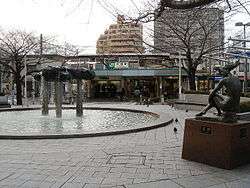
The east exit of Itabashi Station | ||
| ||
 Location of Itabashi in Tokyo Metropolis | ||
 Itabashi Location in Japan | ||
| Coordinates: 35°46′N 139°41′E / 35.767°N 139.683°ECoordinates: 35°46′N 139°41′E / 35.767°N 139.683°E | ||
| Country | Japan | |
| Region | Kantō | |
| Prefecture | Tokyo Metropolis | |
| Government | ||
| • Mayor | Takeshi Sakamoto (since April 2007) | |
| Area | ||
| • Total | 32.22 km2 (12.44 sq mi) | |
| Population (May 1, 2015) | ||
| • Total | 547,270 | |
| • Density | 16,990/km2 (44,000/sq mi) | |
| Time zone | Japan Standard Time (UTC+9) | |
| City hall address |
Itabashi 2-66-1, Itabashi-ku, Tokyo 173-8501 | |
| Website |
www | |
Itabashi (板橋区 Itabashi-ku) is a special ward located in Tokyo Metropolis, Japan. In English, it calls itself Itabashi City. Itabashi has sister-city relations with Burlington, Ontario in Canada; Shijingshan District in Beijing, People's Republic of China; and Bologna in Italy.
As of May 1, 2015, the ward has an estimated population of 547,270 and a population density of 16,990 persons per km². The total area is 32.22 km².
Geography
Itabashi lies on the Kantō plain. The Arakawa River, a major river, forms part of the boundary with Saitama Prefecture. Surrounding the ward are, in Saitama, the cities of Wako and Toda; and in Tokyo, the wards of Nerima, Toshima, and Kita.
History
The name of the ward means "plank bridge" and derives from the wooden span over the Shakujii River that dates from the Heian period. Such a bridge was remarkable at the time, and the name has lasted since. In the Edo period, the Nakasendō crossed the nearby Shimo Itabashi, and the name came to apply to that area as well. Itabashi was one of the Four Edo Post Towns, and travellers first lodged there after leaving the shogunal capital. The Kaga domain had a mansion there. The shogunate maintained the Itabashi execution grounds at Itabashi.
On October 1, 1932, nine towns and villages of Kita-Toshima District were merged and became part of Tokyo City as Itabashi Ward. It became a special ward May 3, 1947. On August 1 of that year, the localities of Nerima, Kami-Nerima, Naka-Arai, Shakujii and Ōizumi were split off from Itabashi to create Nerima Ward.
Education
Universities
Itabashi is home to four universities. Tokyo Kasei University has a campus in the Kaga neighborhood. Also in Kaga is the main campus of Teikyo University. Daito Bunka University has one campus in Takashima-daira, and another in Higashimatsuyama, Saitama. The fourth is the medical college of Nihon University.
Public schools
Public elementary and middle schools are operated by the Itabashi Board of Education.
Public high schools are operated by the Tokyo Metropolitan Board of Education.
- Itabashi High School
- Itabashi Yutoku
- Kitatoshima Technical High School
- Kitazono High School
- Ohyama High School
- Takashima High School
Private schools
- Tokyo Third Korean Elementary School (東京朝鮮第三初級学校) - North Korean school[1]
Points of interest
- Akatsuka Botanical Garden
- Itabashi Botanical Garden
- Jorenji temple and the Daibutsu of Tokyo
Transportation
Rail
- East Japan Railway Company (JR East) Saikyō Line: Itabashi Station, Ukima-Funado Station
- Toei Mita Line: Shin-Itabashi, Itabashi Kuyakusho-mae, Itabashi-Honchō, Moto-Hasunuma, Shimura Sakaue, Shimura-Sanchōme, Hasune, Nishidai, Takashimadaira, Shin-Takashimadaira, Nishi-Takashimadaira Stations
- Tokyo Metro Yūrakuchō Line: Chikatetsu Narimasu Station
- Tōbu Tōjō Line: Ōyama, Naka-Itabashi, Tokiwadai, Kami-Itabashi, Tobu-Nerima, Shimo-Akatsuka, Narimasu Stations
Some of these stations straddle the boundaries with other wards, or are within walking distance of Itabashi. The addresses of some stations are in neighboring wards. Shimo-Itabashi Station is in Toshima; Kotake Mukaihara Station and Akatsuka Subway Station are in Nerima; Ukima-Funado Station is actually in Kita.
Highways
- Shuto Expressway
- No.5 Ikebukuro Route (Takebashi JCT – Bijogi JCT)
- C2 Central Loop (Itabashi JCT – Kasai JCT)
See also
Cities with the same kanji (板橋, read Itabashi during Japanese rule):
References
External links
| Wikimedia Commons has media related to Itabashi, Tokyo. |
| Wikivoyage has a travel guide for North Tokyo. |
- Itabashi City official website (English)
- Itabashi City Home Page (Japanese)