Saitama, Saitama
| Saitama さいたま市 | ||
|---|---|---|
| Designated city | ||
| Saitama City | ||
|
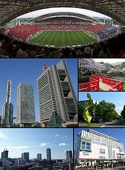
From top left: Saitama Stadium 2002, Saitama New City Center, Saitama Super Arena, Iwatsuki Castle Park, Hikawa Shrine, Urawa PARCO | ||
| ||
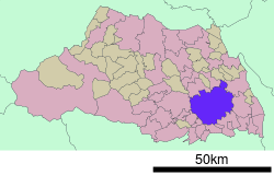 Location of Saitama in Saitama Prefecture | ||
 Saitama Location of Saitama in Saitama Prefecture | ||
| Coordinates: 35°51′41″N 139°38′44″E / 35.86139°N 139.64556°ECoordinates: 35°51′41″N 139°38′44″E / 35.86139°N 139.64556°E | ||
| Country | Japan | |
| Region | Kantō | |
| Prefecture | Saitama Prefecture | |
| Area | ||
| • Total | 217.43 km2 (83.95 sq mi) | |
| Population (February 2016) | ||
| • Total | 1,266,656 | |
| • Density | 5,830/km2 (15,100/sq mi) | |
| Time zone | Japan Standard Time (UTC+9) | |
| - Tree | Zelkova serrata | |
| - Flower | Primula sieboldii | |
| Phone number | 048-829-1111 | |
| Address | 6-4-4 Tokiwa, Urawa-ku, Saitama-shi, Saitama-ken 330-9588 | |
| Website | Official website | |

Saitama (さいたま市 Saitama-shi) is the capital and the most populous city of Saitama Prefecture in Japan, situated in the south-east of the prefecture. Its area incorporates the former cities of Urawa, Ōmiya, Yono and Iwatsuki. It is a city designated by government ordinance. Being in the Greater Tokyo Area and lying 15 - 30 kilometres north of central Tokyo, many of its residents commute into Tokyo. As of 1 February 2016, the city had an estimated population of 1,226,656 and a population density of 5830 persons per km². Its total area was 217.43 square kilometres (83.95 sq mi).
History
The city was founded on May 1, 2001, and was designated on April 1, 2003 as a government ordinance. For the histories of Urawa, Ōmiya and Yono before the merger, see:
- Urawa-ku, Saitama
- Ōmiya-ku, Saitama and
- Yono, Saitama, respectively.
On April 1, 2005, Saitama absorbed the city of Iwatsuki to its east, which became a new ward, Iwatsuki-ku.
Name
The name "Saitama" originally comes from the Sakitama (埼玉郡) district of what is now the city of Gyōda in the northern part of what is now known as Saitama Prefecture. "Sakitama" has an ancient history and is mentioned in the famous 8th century poetry anthology Man'yōshū. The pronunciation has changed from Sakitama to Saitama over the years.
With the merger of Urawa, Ōmiya, and Yono it was decided that a new name, one fitting for this newly created prefectural capital, was needed. The prefectural name "Saitama" (埼玉県) was changed from kanji into hiragana, thus Saitama City (さいたま市) was born. It is the only prefectural capital in Japan whose name is always written in hiragana, and belongs to the list of hiragana cities.
However, Saitama written in hiragana (さいたま市) actually finished in second place in public polling to Saitama written in kanji (埼玉市). Despite this, government officials decided to name the new city Saitama in hiragana, not kanji. In third place in the poll was Ōmiya (大宮市). In fourth was Saitama (彩玉市), written with an alternative kanji for "sai" (彩) which means "colorful". The "sai" (埼) used in the prefectural name is a rare form of a common character (崎) that means cape or promontory.
Geography
The city is located 20 to 30 km north of central Tokyo, roughly at the center of the Kantō Plain. Situated in approximately the center of Saitama Prefecture, the city is topographically comprised by lowlands and plateaus, mostly falling below 20 m above sea level, with no mountain ranges or hills within the city boundaries. The western portion of the city lies on the lowland created by the Arakawa River along with those created by small rivers such as the Moto-Arakawa River, Shiba River, and Ayase River. The rest of the area mostly resides on the Ōmiya Plateau lying in the north-south direction. Dispersed in this region, major rivers flow southward, almost paralleling to one another.
Surrounding municipalities
- Saitama Prefecture
Climate
| Climate data for Saitama City(1981 - 2010) | |||||||||||||
|---|---|---|---|---|---|---|---|---|---|---|---|---|---|
| Month | Jan | Feb | Mar | Apr | May | Jun | Jul | Aug | Sep | Oct | Nov | Dec | Year |
| Record high °C (°F) | 18.7 (65.7) |
25.5 (77.9) |
25.4 (77.7) |
31.2 (88.2) |
33.3 (91.9) |
35.9 (96.6) |
38.7 (101.7) |
37.9 (100.2) |
37.4 (99.3) |
32.1 (89.8) |
25.6 (78.1) |
25.1 (77.2) |
38.7 (101.7) |
| Average high °C (°F) | 9.2 (48.6) |
9.9 (49.8) |
13.1 (55.6) |
19.0 (66.2) |
23.2 (73.8) |
26.0 (78.8) |
29.8 (85.6) |
31.5 (88.7) |
27.1 (80.8) |
21.6 (70.9) |
16.2 (61.2) |
11.7 (53.1) |
19.9 (67.8) |
| Daily mean °C (°F) | 3.6 (38.5) |
4.4 (39.9) |
7.8 (46) |
13.4 (56.1) |
18.0 (64.4) |
21.5 (70.7) |
25.1 (77.2) |
26.6 (79.9) |
22.7 (72.9) |
16.9 (62.4) |
11.0 (51.8) |
5.9 (42.6) |
14.8 (58.6) |
| Average low °C (°F) | −1.5 (29.3) |
−0.6 (30.9) |
2.8 (37) |
8.1 (46.6) |
13.4 (56.1) |
17.7 (63.9) |
21.5 (70.7) |
22.9 (73.2) |
19.2 (66.6) |
12.8 (55) |
6.2 (43.2) |
0.8 (33.4) |
10.3 (50.5) |
| Record low °C (°F) | −7.8 (18) |
−8.7 (16.3) |
−5 (23) |
−2 (28) |
4.8 (40.6) |
11.5 (52.7) |
14.7 (58.5) |
17.1 (62.8) |
9.5 (49.1) |
3.6 (38.5) |
−2.4 (27.7) |
−6.7 (19.9) |
−8.7 (16.3) |
| Average precipitation mm (inches) | 37.4 (1.472) |
43.1 (1.697) |
90.9 (3.579) |
102.3 (4.028) |
117.3 (4.618) |
142.4 (5.606) |
148.1 (5.831) |
176.3 (6.941) |
201.8 (7.945) |
164.9 (6.492) |
75.7 (2.98) |
41.1 (1.618) |
1,346 (52.992) |
| Average precipitation days (≥ 1.0 mm) | 3.9 | 5.2 | 9.5 | 9.8 | 10.3 | 11.6 | 12.1 | 8.7 | 11.5 | 9.6 | 6.7 | 3.9 | 102.8 |
| Mean monthly sunshine hours | 193.3 | 179.9 | 177.8 | 185.7 | 174.7 | 128.2 | 145.5 | 173.0 | 128.1 | 137.0 | 154.5 | 182.9 | 1,960.9 |
| Source #1: Japan Meteorological Agency | |||||||||||||
| Source #2: 観測史上1〜10位の値(年間を通じての値) | |||||||||||||
Wards
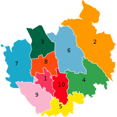
Saitama has ten wards (ku), which were assigned official colours as of April 2005:
| ■1 - Chūō-ku | 中央区 | (Rose red) |
| ■2 - Iwatsuki-ku | 岩槻区 | (Ochre) |
| ■3 - Kita-ku | 北区 | (Dark green) |
| ■4 - Midori-ku | 緑区 | (Green) |
| ■5 - Minami-ku | 南区 | (Lemon yellow) |
| ■6 - Minuma-ku | 見沼区 | (Sky blue) |
| ■7 - Nishi-ku | 西区 | (Blue) |
| ■8 - Ōmiya-ku | 大宮区 | (Orange) |
| ■9 - Sakura-ku | 桜区 | (Cherry blossom pink) |
| ■10 - Urawa-ku | 浦和区 | (Red) - administrative center |
Economy
Saitama's economy is principally constituted by commercial business. The city is one of many commercial centers of the Greater Tokyo area and serves Saitama Prefecture, North Kantō, and northeast Honshū.
Saitama is also home to various manufacturers, exporting automotive (Honda manufactures the Honda Legend here), food, optical, precision and pharmaceutical products. Calsonic Kansei, a global automotive company is headquartered in the city.[1] Iwatsuki is famous for manufacturing of hinamatsuri dolls and ornate kabuto (samurai helmets).
Transportation
Saitama is a regional transportation hub for both passengers and freight train lines. Ōmiya Station, part of the Shinkansen high-speed train network, serves as the biggest railway hub in the prefecture.
The closest major airports are Haneda Airport and Narita International Airport, both about two hours away.[2] Honda Airport in Okegawa is for general aviation and offers no scheduled transport services. Commuter helicopter flights to Narita Airport are offered from Kawajima.[3]
Railway Stations
- ■ East Japan Railway Company
- ■ Tōhoku, Akita, Yamagata, Jōetsu and Nagano Shinkansen
- - Ōmiya -
- ■ Utsunomiya Line
- - Urawa - Saitama-Shintoshin - Ōmiya - Toro - Higashi-Ōmiya -
- ■ Takasaki Line
- - Urawa - Saitama-Shintoshin - Ōmiya - Miyahara -
- ■ Keihin-Tōhoku Line
- - Minami-Urawa - Urawa - Kita-Urawa - Yono - Saitama-Shintoshin - Ōmiya
- ■ Saikyō Line
- - Musashi-Urawa - Naka-Urawa - Minami-Yono - Yonohommachi - Kita-Yono - Ōmiya
- ■ Musashino Line
- - Nishi-Urawa - Musashi-Urawa - Minami-Urawa - Higashi-Urawa -
- ■ Kawagoe Line
- Ōmiya - Nisshin - Nishi-Ōmiya - Sashiōgi -
- ■ Saitama Railway Corporation
- ■ Saitama Rapid Railway Line
- ■ Tobu Railway
- ■ Tōbu Noda Line
- Ōmiya - Kita-Ōmiya - Ōmiya-kōen - Ōwada - Nanasato - Iwatsuki - Higashi-Iwatsuki -
- ■ Saitama New Urban Transit
- ■ New Shuttle
- Ōmiya - Tetsudō-Hakubutsukan - Kamonomiya - Higashi-Miyahara - Konba - Yoshinohara
Highways
- Tohoku Expressway
- Tokyo Gaikan Expressway
- Shuto Expressway
- Japan National Route 16
- Japan National Route 17
- Japan National Route 122
- Japan National Route 293
- Japan National Route 463
Politics and government
The executive mayor, who is directly elected, is Sōichi Aikawa, an independent backed by the Liberal Democratic Party and Komeito. On May 24, 2009, Aikawa lost his bid for reelection against Hayato Shimizu, who was backed by the opposition DPJ.[4] The city assembly of Saitama has 64 elected members.
Elections
Culture
Education
Universities
- Mejiro University
- Nihon University Faculty of Law
- The Open University of Japan Omiya Study Center
- Saitama University
- Shibaura Institute of Technology
- University of Human Arts and Sciences
- Urawa University
- Nippon Institute of Technology
Junior Colleges
- Kokusai Gakuin Saitama Junior College
- Urawa University Junior College
Professional Graduate School
Sports
Saitama is home to two J. League football (soccer) teams: the popular Urawa Red Diamonds, formerly owned by Mitsubishi, and Omiya Ardija, formerly owned by NTT.
The city and Tokorozawa are home to the Japan Professional Basketball League team the Saitama Broncos.
- Urawa Red Diamonds - J. League football (soccer)
- Omiya Ardija - J. League football (soccer)
- Saitama Broncos - bj league basketball (The base is Saitama Prefecture, main is Saitama, Tokorozawa.)
- Saitama Seibu Lions - NPB (baseball)
Since 2013, the city has hosted the Saitama Criterium cycling race sponsored by the Tour de France, held at the end of October.
Mass media
Most of Saitama Prefecture's mass media presence is concentrated in this city. See Mass media in Saitama Prefecture for details.
Sister cities
Saitama has seven sister cities.[5]
-
 Toluca, Mexico (1979)
 -
 Zhengzhou, China (1981)
 -
 Hamilton, New Zealand (1984)
 -
 Richmond, Virginia, United States (1994)
 -
 Nanaimo, British Columbia, Canada (1996)
 - Pittsburgh, Pennsylvania, United States (1998)
-
 Balzers, Liechtenstein (2000)
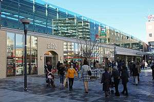
Visitor attractions

- Akigase Park
- Besshonuma Park
- Hikawa Shrine
- John Lennon Museum
- Minuma Rice Paddies
- Minuma Tsūsen-bori
- Ōmiya Bonsai Village
- Railway Museum
- Saitama New Urban Center
- Saitama Stadium 2002
- Saitama Super Arena
- Saitama Museum of Modern Art
References
- ↑ "Company Profile." Calsonic Kansei. Retrieved on January 29, 2015.
- ↑ Haneda bus and Narita bus
- ↑ Connecting TOKYO and Narita Int'l Airport - NARITA HELI EXPRESS
- ↑ "DPJ Triumphs in Saitama Election", The Japan Times, 25 May 2009.
- ↑ 姉妹友好都市 [Sister Cities] (in Japanese). Saitama Tourism and International Relations Bureau. Retrieved 12 May 2013.
External links
| Wikimedia Commons has media related to Saitama, Saitama. |
| Wikivoyage has a travel guide for Saitama. |
- Saitama City official website (Japanese)
| Wards of Saitama | ||
|---|---|---|
| Core cities | ||
| Special cities | ||
| Cities | ||
| Chichibu District | ||
| Hiki District | ||
| Iruma District | ||
| Kitaadachi District | ||
| Kitakatsushika District | ||
| Kodama District | ||
| Minamisaitama District | ||
| Ōsato District | ||