Brownsville, Kentucky
| Brownsville, Kentucky | |
|---|---|
| City | |
|
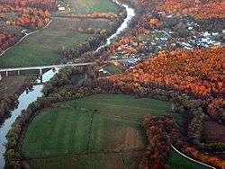
Aerial photograph of Brownsville | |
 Location of Brownsville, Kentucky | |
| Coordinates: 37°11′28″N 86°15′40″W / 37.19111°N 86.26111°WCoordinates: 37°11′28″N 86°15′40″W / 37.19111°N 86.26111°W | |
| Country | United States |
| State | Kentucky |
| County | Edmonson |
| Established | 1826[1] |
| Government | |
| Area | |
| • Total | 2.62 sq mi (6.78 km2) |
| • Land | 2.61 sq mi (6.77 km2) |
| • Water | 0.008 sq mi (0.02 km2) |
| Elevation | 545 ft (166 m) |
| Population (2010) | |
| • Total | 836 |
| • Density | 320/sq mi (123.6/km2) |
| Time zone | Central (CST) (UTC-6) |
| • Summer (DST) | CDT (UTC-5) |
| ZIP code | 42210[2] |
| Area code(s) | 270 & 364 |
| FIPS code | 21-10324 |
| GNIS feature ID | 0488045 |
Brownsville is a 5th-class city in Edmonson County, Kentucky, in the United States. It is the county seat.[3] The population was 836 at the time of the 2010 census,[4] down from 921 at the 2000 census. It is included in the Bowling Green metropolitan area.[5] It is just outside Mammoth Cave National Park.[6]
Geography
Brownsville is located near the center of Edmonson County at 37°11′28″N 86°15′40″W / 37.191169°N 86.261098°W.[7] The city limits border the western edge of Mammoth Cave National Park, with access to Houchin Ferry Campground.
State Routes 70 and 259 pass through the city together as Main Street. KY 70 leads east 20 miles (32 km) to Cave City and west 27 miles (43 km) to U.S. Route 231 at Aberdeen, while KY 259 leads southeast 12 miles (19 km) to U.S. Route 31W and north 25 miles (40 km) to Leitchfield.
According to the United States Census Bureau, Brownsville has a total area of 2.6 square miles (6.8 km2), of which 0.01 square miles (0.02 km2), or 0.26%, is water.[4] The city is located on the Green River, a tributary of the Ohio River.[1]
Demographics
| Historical population | |||
|---|---|---|---|
| Census | Pop. | %± | |
| 1830 | 229 | — | |
| 1840 | 112 | −51.1% | |
| 1880 | 116 | — | |
| 1890 | 113 | −2.6% | |
| 1900 | 234 | 107.1% | |
| 1910 | 313 | 33.8% | |
| 1920 | 294 | −6.1% | |
| 1930 | 359 | 22.1% | |
| 1940 | 451 | 25.6% | |
| 1950 | 447 | −0.9% | |
| 1960 | 473 | 5.8% | |
| 1970 | 542 | 14.6% | |
| 1980 | 674 | 24.4% | |
| 1990 | 897 | 33.1% | |
| 2000 | 921 | 2.7% | |
| 2010 | 836 | −9.2% | |
| Est. 2015 | 826 | [8] | −1.2% |
As of the census of 2000, there were 921 people, 387 households, and 229 families residing in the city. The population density was 581.0 people per square mile (223.6/km²). There were 421 housing units at an average density of 265.6 per square mile (102.2/km²). The racial makeup of the city was 98.37% White, 0.11% African American, 0.43% Native American, 0.11% Asian, 0.11% from other races, and 0.87% from two or more races. Hispanic or Latino of any race were 0.76% of the population.
There were 387 households out of which 26.4% had children under the age of 18 living with them, 40.6% were married couples living together, 16.8% had a female householder with no husband present, and 40.6% were non-families. 37.5% of all households were made up of individuals and 15.8% had someone living alone who was 65 years of age or older. The average household size was 2.15 and the average family size was 2.81.
In the city the population was spread out with 20.3% under the age of 18, 8.6% from 18 to 24, 22.8% from 25 to 44, 24.4% from 45 to 64, and 23.9% who were 65 years of age or older. The median age was 43 years. For every 100 females there were 72.5 males. For every 100 females age 18 and over, there were 71.1 males.
The median income for a household in the city was $15,370, and the median income for a family was $21,250. Males had a median income of $26,125 versus $14,583 for females. The per capita income for the city was $15,711. About 30.8% of families and 32.6% of the population were below the poverty line, including 45.2% of those under age 18 and 24.5% of those age 65 or over.
Plain community
There is a Plain, horse and buggy community with about 40 to 50 people in Peace Valley, Brownsville. The community is affiliated with the Caneyville Christian Community.
Education
Brownsville is served by the Edmonson County Schools.[10] Schools in the district located in Brownsville are:
- Edmonson County High School[11] (Principal:Tommy Hodges;[12] Assistant Principal:Patricia Sharp[12]
- Edmonson County Middle School[13] (Principal:Brandon Prunty[14])
- Edmonson County 5th/6th Center[15] (Principal:Allan Talley.[16]
References
- 1 2 Kentucky, University of. "Brownsville, Kentucky". Gazetteer, Kentucky Atlas and. Retrieved 2010-04-15.
- ↑ Inc., Advameg (2010). "Brownsville, Kentucky (KY 42210) profile". Retrieved 2010-04-15.
- ↑ "Find a County". National Association of Counties. Archived from the original on 2011-05-31. Retrieved 2011-06-07.
- 1 2 "Geographic Identifiers: 2010 Demographic Profile Data (G001): Brownsville city, Kentucky". American Factfinder. U.S. Census Bureau. Retrieved January 29, 2016.
- ↑ Management and Budget, Office of (2008-11-20). "OMB BULLETIN NO. 09-01" (PDF). the President, Executive Office of. Retrieved 2010-04-15.
- ↑ Service, National Park. "Mammoth Cave National Park Map" (PDF). Retrieved 2010-04-15.
- ↑ "US Gazetteer files: 2010, 2000, and 1990". United States Census Bureau. 2011-02-12. Retrieved 2011-04-23.
- ↑ "Annual Estimates of the Resident Population for Incorporated Places: April 1, 2010 to July 1, 2015". Retrieved July 2, 2016.
- ↑ "Census of Population and Housing". Census.gov. Archived from the original on May 11, 2015. Retrieved June 4, 2015.
- ↑ Education, Kentucky Department of (2009-10-29). "County & Independent School Districts" (PDF). Kentucky, Commonwealth of. Archived from the original (PDF) on 2010-01-10. Retrieved 2010-04-15.
- ↑ Edmonson County High Schools. "Edmonson County High School". Retrieved 2010-04-15.
- 1 2 Edmonson County High School. "Edmonson County High School". Retrieved 2010-04-15.
- ↑ Edmonson County Middle School (2010-03-29). "ECMS Home Page". Retrieved 2010-04-15.
- ↑ School-Based Decision-Making Council, Edmonson County Middle School (2010-02-05). "ECMS SBDM Council". Retrieved 2010-04-15.
- ↑ 5th/6th Center, Edmonson County (2009-08-19). "Welcome to the Frontpage". Retrieved 2010-04-15.
- ↑ 5th/6th Center, Edmonson County (2009-09-23). "Teachers". Retrieved 2010-04-15.
External links
- Brownsville at the U.S. Geographic Names Information System
| Wikivoyage has a travel guide for Brownsville, Kentucky. |
Municipalities and communities of Edmonson County, Kentucky, United States | ||
|---|---|---|
| City | 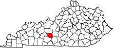 | |
| Unincorporated communities | ||
| Principal city | _Metro.png) | |
|---|---|---|
| Other municipalities | ||
| Counties | ||
