Morehead, Kentucky
| Morehead, Kentucky | |
|---|---|
| City | |
|
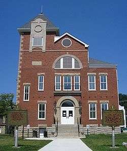
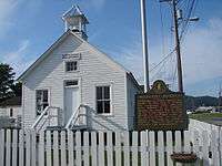
Rowan County Arts Center in Morehead. (Formerly Rowan County Courthouse) | |
 Location of Morehead, Kentucky | |
| Coordinates: 38°11′1″N 83°26′28″W / 38.18361°N 83.44111°WCoordinates: 38°11′1″N 83°26′28″W / 38.18361°N 83.44111°W | |
| Country | United States |
| State | Kentucky |
| County | Rowan |
| Incorporated | 1869[1] |
| Named for | Gov. James Morehead |
| Area | |
| • Total | 9.3 sq mi (24.0 km2) |
| • Land | 9.2 sq mi (23.9 km2) |
| • Water | 0.0 sq mi (0.1 km2) |
| Elevation | 738 ft (225 m) |
| Population (2010) | |
| • Total | 6,845 |
| • Density | 640.8/sq mi (247.4/km2) |
| Time zone | Eastern (EST) (UTC-5) |
| • Summer (DST) | EDT (UTC-4) |
| ZIP code | 40351 |
| Area code(s) | 606 |
| FIPS code | 21-53418 |
| GNIS feature ID | 0514051 |
| Website | morehead-ky.gov |
Morehead is a home rule-class city[2] located along US 60 (the historic Midland Trail) and Interstate 64 in Rowan County, Kentucky, in the United States. It is the seat of its county.[3] The population was 6,845 at the time of the 2010 U.S. census.[4]
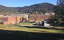
It was the focal point of the Rowan County War and is the home of Morehead State University.
History
Initial settlement
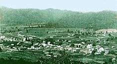
The first settlers came to Rowan County from Virginia following the end of the American Revolutionary War in 1783. In 1854, Morehead became the third community to be settled in the county.[5] Colonel John Hargis founded the city after purchasing land in the area.[6] The city was named after James T Morehead, a politician who served as governor of Kentucky from 1834 to 1836.[7] Rowan County came into existence in May 1856, seceding from parts of Morgan County and Fleming County. It was divided into four districts with Morehead being declared the county seat.[8] The formation of Rowan County was a political ploy to prevent Flemingsburg from moving its seat to Poplar Plains, and Morehead was selected as Rowan's seat because of its centrality.[9] Although it was smaller and less developed than the neighboring town of Farmers, it remained a significant city in the county due its status as county seat.[6] It was officially incorporated in 1869.[9]
Rowan County War
In the 1880s, Morehead became the central stage for a notorious conflict known as the Rowan County War or the Martin–Tolliver–Logan Feud. During a number of skirmishes for the next few years, at least 20 people were killed and possibly 100 were wounded. Beginning with an election-day barroom brawl, several gunfights took place in Morehead and the surrounding countryside. Eventually, a group led by Craig Tolliver seized political control of the town and installed allies in the county sheriff's and county attorney's offices as well as at the office of the town marshal. Several members of the opposing faction were arrested on trumped-up charges, and some were killed when the faction in power falsely claimed they had resisted arrest. The conflict gained national attention and on two occasions the governor sent troops to maintain order with little effect. Eventually a posse of as many as 100 individuals were organized and armed by Daniel Boone Logan with the tacit consent of Gov. J. Proctor Knott and Governor-elect Simon Buckner. In a dramatic two-hour gun battle through the center of Morehead, several Tollivers (including Craig) were killed and the Tollivers' control of the county was broken. Two men were later acquitted for the murder of Craig Tolliver.[10][11] Morehead State University was established as an indirect result of the feud. After the state militia came to settle the feud, the Disciples of Christ established a church and school which served as the forerunner to the university.[12]
20th century

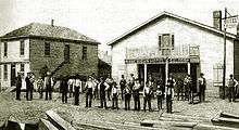
The industry improved in the early 20th century. It was considered an important shipping center in the region, and the city of Chesapeake, Ohio even carried out developments on the road system of Morehead. Its abundance of lumber, fire clay, farm products and gas made it an active center of industry, of which was mainly oriented towards agriculture. The close proximity of the Licking River helped ensure the population would flourish.[13] In the 1920s, the city refocused its efforts towards fire clay extraction amidst the dwindling prices of timber. One of the first transcontinental auto trails in the USA, the Midland Trail, was connected to Morehead in 1929.[14]
In July 1939, a number of business and hotels located on Mainstreet were caught in a raging fire following Independence Day celebrations which went awry. Only 24 hours afterwards, the town was badly affected by flash flooding.[15] At least 25 people died, and thousands had to receive vaccinations for Typhoid fever. The property costs incurred by the flooding were estimated at $1,000,000, while the damage inflicted on crops and farms caused an economic loss of about $500,000.[16]
In the early 1960s, efforts were underway to establish a local hospital. An agreement was eventually reached with the Sisters of Notre Dame in Covington, Kentucky in which the sisters would assume responsibility for operating the proposed hospital. In July 1963, St Claire's Medical Center was opened with a 41-bed capacity.[17] Transport in and out of the city was greatly improved in 1969 after the completion of Interstate 64 to the north.[14]
After the logging and extraction industries lost momentum in eastern Kentucky during the mid-1900s, the city invested heavily in developing Morehead State University as a means to secure economic growth.[14] Morehead also sought to capitalize on tourism by ameliorating its natural attractions. Hiking trails were created through Cave Run Lake in the 1960s and 1970s,[18] and in 1974, tourism was further boosted when Cave Run Lake was impounded by the city.[12] By 1990, Morehead State University had become the largest employer in the city.[14]
21st century
In 2015, Kim Davis of Morehead gained international attention after she defied a federal court order requiring that as Clerk of Rowan County she issue a marriage license to a same-sex couple.[19]
Religion
As of 2000, Rowan County was the home of 25 Evangelical churches, four Mainline Protestant churches, one Catholic Church and one Church of Jesus Christ of Latter-day Saints (LDS) congregation. This represents a net increase of five congregations. Six congregations (all Evangelical) were established between 1990 and 2000, while one (also an Evangelical congregation) closed.[20]
Rowan County is ranked 113th (of 120 counties in Kentucky) in overall rates of adherence, with only 249 out of every 1000 residents claimed as an adherent of a religious congregation. 129 of every 1000 residents was claimed by an Evangelical congregation (116th in rank), 50 by a Mainline congregation (91st in rank), 20 by the Catholic Church, and 37 by the Church of Jesus Christ of Latter-Day Saints. A small number of other residents belonged to religious groups not represented in one of these categories.[21]
Geography
Topography
According to the United States Census Bureau, Morehead has a total area of 9.3 square miles (24 km2), of which 9.2 square miles (24 km2) is land.
Morehead is in the foothills of the Appalachian Mountains.[12] The topography of the area represents a mixture of the Highland Rim and the western border of the Eastern Kentucky Coalfield. The highest elevation in the county is Limestone Knob (1435 ft), situated approximately 3 miles southwest of Morehead. The elevation of the city is 748 ft.[22]
Climate
| Climate data for Morehead, Kentucky | |||||||||||||
|---|---|---|---|---|---|---|---|---|---|---|---|---|---|
| Month | Jan | Feb | Mar | Apr | May | Jun | Jul | Aug | Sep | Oct | Nov | Dec | Year |
| Record high °F (°C) | 80 (27) |
81 (27) |
89 (32) |
93 (34) |
95 (35) |
104 (40) |
105 (41) |
106 (41) |
103 (39) |
96 (36) |
85 (29) |
79 (26) |
106 (41) |
| Average high °F (°C) | 41 (5) |
47 (8) |
57 (14) |
67 (19) |
76 (24) |
84 (29) |
88 (31) |
87 (31) |
80 (27) |
69 (21) |
57 (14) |
47 (8) |
66.7 (19.3) |
| Average low °F (°C) | 22 (−6) |
24 (−4) |
32 (0) |
40 (4) |
50 (10) |
59 (15) |
63 (17) |
62 (17) |
55 (13) |
42 (6) |
35 (2) |
27 (−3) |
42.6 (5.9) |
| Record low °F (°C) | −28 (−33) |
−19 (−28) |
−9 (−23) |
16 (−9) |
25 (−4) |
35 (2) |
43 (6) |
35 (2) |
29 (−2) |
13 (−11) |
0 (−18) |
−24 (−31) |
−28 (−33) |
| Average precipitation inches (mm) | 3.40 (86.4) |
3.27 (83.1) |
4.07 (103.4) |
3.91 (99.3) |
4.86 (123.4) |
4.55 (115.6) |
5.60 (142.2) |
3.78 (96) |
3.23 (82) |
3.16 (80.3) |
3.47 (88.1) |
4.03 (102.4) |
47.33 (1,202.2) |
| Source: The Weather Channel.[23] | |||||||||||||
Demographics
| Historical population | |||
|---|---|---|---|
| Census | Pop. | %± | |
| 1880 | 163 | — | |
| 1890 | 491 | 201.2% | |
| 1900 | 1,100 | 124.0% | |
| 1910 | 1,105 | 0.5% | |
| 1920 | 981 | −11.2% | |
| 1930 | 825 | −15.9% | |
| 1940 | 1,901 | 130.4% | |
| 1950 | 3,102 | 63.2% | |
| 1960 | 4,170 | 34.4% | |
| 1970 | 7,191 | 72.4% | |
| 1980 | 7,789 | 8.3% | |
| 1990 | 8,357 | 7.3% | |
| 2000 | 5,914 | −29.2% | |
| 2010 | 6,845 | 15.7% | |
| Est. 2015 | 7,045 | [24] | 2.9% |
As of the census[26] of 2000, there were 5,914 people, 2,114 households, and 1,101 families residing in the city. The population density was 640.8 people per square mile (247.4/km²). There were 2,347 housing units at an average density of 254.3 per square mile (98.2/km²). The racial makeup of the city was 94.25% White, 2.57% African American, 0.15% Native American, 1.52% Asian, 0.02% Pacific Islander, 0.12% from other races, and 1.37% from two or more races. Hispanic or Latino of any race were 0.76% of the population.
There were 2,114 households out of which 23.6% had children under the age of 18 living with them, 38.2% were married couples living together, 11.2% had a female householder with no husband present, and 47.9% were non-families. 36.1% of all households were made up of individuals and 13.3% had someone living alone who was 65 years of age or older. The average household size was 2.14 and the average family size was 2.81.
In the city the population was spread out with 15.5% under the age of 18, 34.6% from 18 to 24, 20.6% from 25 to 44, 16.6% from 45 to 64, and 12.7% who were 65 years of age or older. The median age was 25 years. For every 100 females there were 88.5 males. For every 100 females age 18 and over, there were 87.6 males.
The median income for a household in the city was $24,014, and the median income for a family was $34,375. Males had a median income of $23,950 versus $19,455 for females. The per capita income for the city was $13,415. About 16.7% of families and 26.0% of the population were below the poverty line, including 19.8% of those under age 18 and 15.6% of those age 65 or over.
Tourism
In 1974, tourism was boosted by the impoundment of Cave Run Lake, the largest lake in Eastern Kentucky.[12][27] A council, called Morehead-Rowan County Economic Development Council, was formed in 1991 in order to attract more industry and capitalize on tourism to Cave Run Lake.[12] Hiking trails dating back to the 1960s and 1970s are still maintained for foot traffic around Cave Run Lake, however, officials are attempting to address the difficulties faced by cyclists and horseback riders crossing the trails.[18]
In 2012, Morehead became a trail town, rerouting the Sheltowee Trace Trail through it. This gives trail users the ability to explore the town and get what they may need before heading back on the trail.[28]
There are more than thirty cycling trails in the county's section of Daniel Boone National Forest.[29]
Education
There are currently 9 public primary schools operating in Morehead, including:[30]
- Bluegrass Discovery Academy
- McBrayer Elementary
- Morehead Youth Development Center
- Rodburn Elementary
- Rowan County Middle School
- Rowan County Preschool Center
- Rowan County Senior High School
- Sunrise Children's Services
- Tilden Hogge Elementary School
Additionally, there are two institutions for higher education situated in the city. Morehead State University was established in 1887, and offers more than 100 degree programs.[31] There is also a campus for Maysville Community and Technical College in the city.[30]
Media
Newspapers
- The Morehead News – Local newspaper.[32]
Radio stations
- W10BM – Local television station, known for Buy a Dog, Sell a Hog.
- W219DI 91.7 - Freedom Radio FM.[33][34] Christian Radio (FM Translator).
- W227AX 93.3 – K-LOVE.[35][36] Contemporary Christian radio (FM Translator).
- WIVY 96.3 – TIMELESS FAVORITES. Local soft adult contemporary format radio station known as "IVY."
- WMKY 90.3 – Morehead State Public Radio. Local NPR flag station which broadcasts to over 20 eastern Kentucky counties.[37] The station includes news coverage, in addition to classical, jazz, blues, americana and bluegrass. Personalities include Carolyn Franzini, Michelle Wallace, Paul Hitchcock and Jesse Wells.
- WMOR-FM 106.1 – Adult rock radio station.[38]
Sister cities
Morehead has city partnerships with the following cities or regions:
Through Sister Cities International, Morehead has one sister city:
See also
References
- ↑ Commonwealth of Kentucky. Office of the Secretary of State. Land Office. "Morehead, Kentucky". Accessed 26 Aug 2013.
- ↑ "Summary and Reference Guide to House Bill 331 City Classification Reform" (PDF). Kentucky League of Cities. Retrieved December 30, 2014.
- ↑ "Find a County". National Association of Counties. Retrieved 2011-06-07.
- ↑ United States Census. "".
- ↑ Thompson, George E. (2009). You Live Where?: Interesting and unusual facts about where we live. iUniverse. p. 236. ISBN 978-1440134210.
- 1 2 Pearce, John Ed (2010). Days of Darkness: The Feuds of Eastern Kentucky. The University Press of Kentucky. ISBN 978-0813126579.
- ↑ Rennick, Robert (1988). Kentucky Place Names. The University Press of Kentucky. ISBN 978-0813101798.
- ↑ "Early history of Rowan County as taken from the records of the first established womens club here". The Rowan County News. 30 April 1936. Retrieved 26 February 2015.
- 1 2 Blair, Juanita; Brown, Fred (2000). The Story of Two Kentucky Feuds.
- ↑ Kentucky Stuarts. "Feud In Rowan County"
- ↑ McConkey, James. Rowan's Progress. Pantheon Books, 1992.
- 1 2 3 4 5 "OUR TOWNS; MOREHEAD; A TOWN SHAPED BY HILLS, HISTORY AND A SCHOOL". The Courier-Journal Louisville, KY. 3 February 1992. Retrieved 27 February 2015.
- ↑ "Home of colleges, churches and culture--is a flourishing little city of 1800 and the county seat of Rowan County--rapidly advancing in commerce and industry.". The Mt. Sterling advocate. 20 July 1910. Retrieved 27 February 2015.
- 1 2 3 4 John E. Kleber, Thomas D. Clark, Lowell H. Harrison and James C. Klotter (1992). "Morehead". The Kentucky Encyclopedia. Lexington: University Press of Kentucky. ISBN 9780813159010.
- ↑ "Morehead remembers 'Kentucky's worst flash flood' on 75th anniversary of deadly event". kyforward.com. 26 June 2014. Retrieved 27 February 2015.
- ↑ "Morehead, KY (Other Areas), Flash Flooding, July 1939". gendisasters.com. Retrieved 27 February 2015.
- ↑ Jeanette M, Bolt D. (September 1988). "A success story in rural Kentucky". Health Progress. 69 (7). PMID 10288937.
- 1 2 "Forest Service seeks comments, hosts open house on Cave Run Trails project". The Morehead News. 13 November 2009. Retrieved 28 January 2016.
- ↑ Jones, Clair (September 13, 2015). "Why Kim Davis Should Not Be the Poster Child for Morehead, Kentucky Beliefs". Huffington Post.
- ↑ Religious Congregations and Membership (2000), conducted by Glennmary Research Center Retrieved on 2010-12-05
- ↑ "County Membership Report". Association of Religious Data Archives. Retrieved 26 July 2015.
- ↑ "Groundwater resources of Rowan County, Kentucky". University of Kentucky. Retrieved 27 February 2015.
- ↑ "MONTHLY AVERAGES for Morehead, KY". The Weather Channel. Retrieved 2010-10-22.
- ↑ "Annual Estimates of the Resident Population for Incorporated Places: April 1, 2010 to July 1, 2015". Retrieved July 2, 2016.
- ↑ "Census of Population and Housing". Census.gov. Retrieved June 4, 2015.
- ↑ "American FactFinder". United States Census Bureau. Retrieved 2008-01-31.
- ↑ "RV Campgrounds in Rowan County, Kentucky". usatoday.com. Retrieved 27 February 2015.
- ↑ "Morehead - Morehead, Kentucky". Kentucky Tourism.
- ↑ "Trails". Morehead Tourism. Retrieved 28 January 2016.
- 1 2 "Public schools in Morehead, KY". National Center for Education Statistics. Retrieved 27 January 2015.
- ↑ "Academics". moreheadstate.edu. Retrieved 27 February 2015.
- ↑ "The Morehead News". The Morehead News.
- ↑ "W219DI-FM 91.7 MHz". radio-locator.com.
- ↑ "Home page". Freedom Radio FM.
- ↑ "W227AX-FM 93.3 MHz". radio-locator.com.
- ↑ "K-LOVE Contemporary Christian Music - K-LOVE". K-LOVE.
- ↑ "MSPR announces new board members". Morehead State News. 27 January 2016. Retrieved 28 January 2016.
- ↑ "WMOR-FM". optiradio.com. Retrieved 28 January 2016.
External links
- City of Morehead - Official website
- Tourism guide to Morehead, Kentucky
Municipalities and communities of Rowan County, Kentucky, United States | ||
|---|---|---|
| Cities | 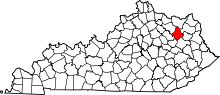 | |
| CDP |
| |
| Other unincorporated communities | ||
